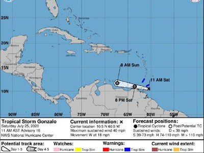
CDEMA Information Note #3 - Tropical Cyclone Gonzalo as of 11:00AM (AST) on July 25th, 2020
NHC Update
According to the National Hurricane Center (NHC) in Miami, Florida, as of 11:00 AM (AST) on July 25, 2020, the center of Tropical Storm Gonzalo was located near latitude 10.5 degrees North, longitude 60.5 degrees West. Gonzalo is moving toward the west near 18 mph (30 km/h). A general westward to west-northwestward motion is expected today and tonight. On the forecast track, Gonzalo will move across the southern Windward Islands this afternoon or evening and over the southeastern Caribbean Sea on Sunday.