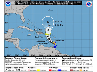
CDEMA Information Note #1 - Tropical Storm Karen as of 2:00PM (AST) on September 22nd, 2019
National Hurricane Center (NHC) Update
According to the National Hurricane Center (NHC) in Miami, Florida, as at 2:00 PM AST, the center of Tropical Storm Karen was located near latitude 12.7 North, longitude 62.3 West. Karen is moving toward the west-northwest near 13 mph (20 km/h) and this general motion is expected to continue today. A turn toward the northwest is forecast to occur on Monday, followed by a turn toward the north on Tuesday. On the forecast track, the center of Karen will move away from the Windward Islands later today, and then across the eastern Caribbean Sea tonight and Monday. On Tuesday, Karen is expected to approach.