

Roads may be affected by various processes related to floods. Mitigation measures are various and depend on local conditions and the size and type of flooding. This use case discusses two locations: the Stowe area (Dominica) and the town of Soufrière (St Lucia). In the Stowe area (Dominica) a road is positioned directly adjacent to the sea where flooding, road embankment, and slope failure problems occur. The town of Soufrière (St Lucia) is directly adjacent to the sea with a water front only 1 to 2 m above water level where flooding by sea and rivers regularly occurs.
Use case intended for: Engineer
Keywords:
Road cut, river wall, sea wall, embankment, road engineering, slope stability, wave action, spray
| Before you start: | Use case Location: | Uses GIS data: | Authors: |
|---|---|---|---|
|
To carry out some of the analysis in this use case, it is required to have hydrological engineering skills and have a basic knowledge of road engineering in order to be able to analyze the implications of roads crossing flooding prone areas. Engineering geological and geotechnical engineering skills may be required to analyze the terrain and design appropriate mitigation measures for roads in flood-prone areas. This use case concerns flooding of roads and mitigation measures in relatively flat areas. In steep terrain roads may be affected also by various processes related to flash floods; these are discussed in use case 3.2.2 Roads in flood affected areas , use case 3.2.3 Roads in landslide affected areas and use case 3.3.3 Landslide mitigation measures for roads. |
Stowe Area, Dominica & Soufrière, St Lucia | Robert Hack, Mark Trigg |
Introduction:
Roads near sea or rivers may be prone to flooding when high water levels occur. Mitigation measures may be required to avoid water on roads or avoid high groundwater levels below roads. The use cases discussed are the Stowe area (Dominica) and the town of Soufrière (St Lucia). In the Stowe area (Dominica) a road is positioned directly adjacent to the sea where flooding, road embankment, and slope failure problems occur. The town of Soufrière (St Lucia) is directly adjacent to the sea with a water front only 1 to 2 m above water level where flooding by sea and rivers regularly occurs. Flooding of roads leads to unusable and dangerous roads, degradation and erosion of pavement and embankment, and danger to the traffic on the road. The use case illustrates the problems and give guidelines on how solutions can be applied.
Objectives:
Determine mitigation measures for protection of a road against flooding and slope failure danger.
Flowchart:
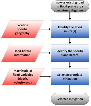
Simple flowchart
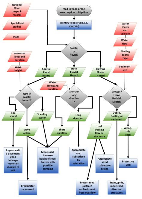
Detailed flowchart
Use case study area description:
Geology
The geology of the areas described in this use case are the Stowe area (Dominica) and the town of Soufrière, St Lucia. The islands Dominica and St Lucia belong to the chain of volcanic islands forming the Lesser Antilles island arc. It is the surface manifestation of the subduction of the North American Plate beneath the Caribbean Plate that was initiated as early lower Eocene (Smith et al., 1980). The general geology of both islands are described below.
Geology of Dominica
The main part of the geology of Dominica consists of sub-aerial lava flows and pyroclastics with minor Pleistocene to Holocene uplifted conglomerates and corals along the west and south coasts of the island (Christian, 2012). A comprehensive K-Ar and carbon dating of the volcanic rocks resulted to the subdivision of the rocks into four units (Smith et al., 2013). The Upper Miocene is dominated by mafic volcanism that make up the eastern part of the island. The Upper Pliocene to Lower Pleistocene unit consists of the deposits of two major stratovolcanoes (proto- Morne Diablotins and Cochrane-Mahaut) and two smaller volcanoes (Morne Concrod and Morne Bois) located on the eastern flank of Mount Diablotins. Lower to Upper Pleistocene is formed by two volcanic centres, Proto- Morne aux Diables in the north and Foundland in the south, and is the least extensive unit on the island. The Upper Pleistocene - Holocene is composed of seven volcanic centres on the island which mark the renewed volcanism producing andesites and dacites.
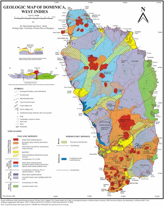
Figure 1: Geology of Dominica (after Roobol & Smith, 2004).
Local geology (Stowe area, Dominica)
From top to bottom the geology along the road in the Stowe area consists generally of recent un-cemented river and slope deposits and cemented river and slope deposits with an irregular erosion surface in-between, underlain by and partially mixed with completely to slightly weathered assorted volcanic rocks including mafic flow rocks (Roobol & Smith, 2004). The topsoil is mostly relatively thin and generally less than 0.5 m.
Geology of St Lucia
St Lucia is almost entirely volcanic with the oldest rocks, largely rhyolite, andesite and various basalt lavas, dating from the early tertiary period about 50 million years ago. Along the east coast some minor amount of sedimentary rocks of lower Miocene age are exposed. Lindsay et al. (2002) based on earlier work of Newman (1965) divided the volcanic rock formations of St Lucia into three broad categories, from oldest to youngest, the Northern, Central, and Southern Series as shown in Figure 2.
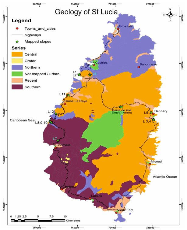
Figure 2: St. Lucia geology and rock formations (after Newman, 1965).
Local geology (Soufrière, St Lucia)
The geology at the bay of Soufrière, St Lucia, consists of rock blocks, (tuff) flow deposits, and fluvial sediments (OAS, 1984).
Problems definition and specifications:
Two different areas with flooding related problems are described. In the Stowe area on Dominica a road has been constructed adjacent to the sea such that the road is regularly flooded by the sea and the road cut made for the road is instable which may be (partially) caused by seawater influence. The other area is in the town of Soufrière on St Lucia, where flooding by the sea is a regular phenomenon.
Stowe area (Dominica)
The Stowe area (Dominica) is mountainous with steep cliffs directly adjacent to the sea (Figure 3). On a natural and in part man-made or reinforced embankment at the toe of the cliffs a road has been constructed partially by making road cuts. It is the Dubuc-Fond St Jean Road, forming the connection between Berekua and Dubuc and further to Petite Savanne, and the Bellevue Chopin road connecting to Fond St Jean. The road is the only direct connection via the South between the West and South of Dominica and Southeast Dominica. The alternative road connection between West/South and Southeast Dominica is more north and involves a long detour (order of 40 km). The road is intensively used by the local inhabitants and for provisioning of the South and Southeast from Roseau. Bikes, cars, trucks, busses, as well as pedestrians, including school-going kids, use the road. Tourists use the road driving and walking and may stop on the road as it is a scenic area. The top of the cliffs are covered with bush and rain forest with few present activities of man, except for some agriculture near the villages. In the past, the tops of the cliffs have been used more intensively as shown by now-overgrown abundant agricultural fields.
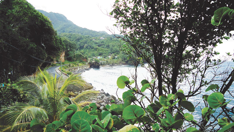
Figure 3: Stowe area, Dominica. Mountainous area with steep cliffs adjacent to the sea (photo Arnoldus, 2014).
Soufrière (St Lucia)
The waterfront of the town of Soufrière, (St Lucia), is directly above seawater level (Figure 4). The town has been severely damaged due to flooding during hurricanes in the past.
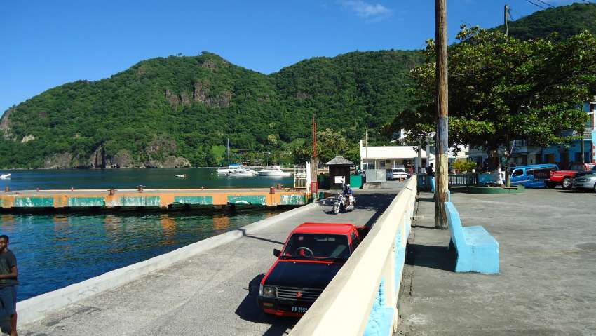
Figure 4: Soufrière, St Lucia. The waterfront of Soufrière is directly above seawater level (photo Arnoldus, 2014).
Data requirements:
The following data are required:
Topographical maps on scale 1:10,000 are required for routing of roads. More detailed topographical maps are required for design and construction and for mitigation measures with scales ranging from 1:1,000 to 1:100. Best to be supplemented by a Lidar or leveled point map with a minimum spatial resolution in the order of 0.2 m in length and width and with height information in the order of centimeters. For roads along rivers and sea bathymetrical depth information is required, with similar resolution as topographical data.
Further are required; the scales are ideal requirements:
On a site scale (meters to tens of meters):
- Detailed geological and geotechnical information
- Type of soil and rock masses and mineral content; the latter to be able to assess the future weathering of the soil and rocks.
On a 1:10,000 scale:
- Flooding hazard data of rivers or sea; including river and seawater level, duration of high water, and wave heights.
On a 1:100,000 scale:
- Climate, prevailing wind directions, and rainfall data; to be able to assess the future weathering of the soils and rocks, to access quantities of water to be expected to run-off over the topography, and to be able to assess variations in groundwater level, if groundwater level data during and after heavy rainfall is not available.
- Groundwater level data
- Earthquake data; including intensity or peak acceleration - frequency data
- Land-use data
- Traffic intensity data
Analysis steps:
Stowe area-Flooding
The origin of the flooding in the Stowe area is coastal. Coastal flooding and problems associated are divided in: standing seawater on the road, seawater level is for a longer timespan at or directly below the pavement level, wave action causing temporarily considerable quantities of water on the road, considerable spray from waves, acceptable spray, influence of salt in seawater, and erosion of road or embankment.
1. Standing seawater on the road.
A road prone to coastal flooding may be overrun by water, i.e. the seawater level is so high that semi-permanent water is present on the road pavement making use of the road difficult or impossible. Data requirements are seawater level and duration of high water. Data requirements are the maximum water height in relation to the road level. Mitigation measures are increasing the height of the road to well above maximum expected sea level (as a general rule more than 25 cm above; see B below) or to make an impermeable barrier (a dike) between the road and sea, with a pumping installation that reduces the water level behind the dike. In the Stowe area the latter is no option as the seafloor is likely to drop too steeply.
2. Seawater level is for a longer timespan at or directly below the pavement level
When seawater level is for a longer timespan at or directly below the pavement level, the pavement and ground below the pavement (the base, sub-base, and/or subgrade of the road) may become saturated with water. The saturation with water causes buoyancy of pavement and ground material and may cause excess pore water pressures when traffic passes over the road, causing breaking up of pavement and allowing displacement of ground material. The displaced ground material will leave voids below the pavement or areas with less support for the pavement. Traffic on the road during but also after the high water will then cause breaking up of the pavement starting with cracks and potholes which may rapidly grow in larger areas of damaged road pavement. Generally problems caused by buoyancy and excess ground water pressures start with a clearance of less than about 25 cm of water level below the pavement but this depends on the permeability of the pavement and base materials. More impermeable material will lead to higher pore water pressures and thus to a more serious problem. Data requirements and mitigation measures are similar as under Step 1.
3. Wave action causing temporarily considerable quantities of water on the road
Wave action may cause (temporarily) considerable quantities of seawater on the road. This may make use of the road impossible or dangerous. For the later should be considered that waves give a temporary water level but also a horizontal force on the traffic whether pedestrians or cars and trucks. The presence of water reduces friction, the temporary water level reduces shear resistance and at the same time horizontal forces due to the moving water act on the traffic. Wave water may also cause saturation of the pavement and ground material below with the resulting damage for the pavement as mentioned under point B. Data requirements are similar to those under point A with the addition of wave height information. Mitigation measures are also similar to those under point A with the addition that breakwater (for example, concrete tetrapot blocks) structures may be installed to reduce height of waves. Alternative is a relatively strong seawall that can withstand the forces of the waves.
4. Considerable spray from waves
Considerable spray from waves may make use of the road difficult or may inflict damage on the pavement due to pore water pressures with the resulting damage as mentioned in Step 2. This point differs from Step 3 as waves will not overflow the road. Data requirements are duration and quantities of spray water. Spray water can be estimated by questioning local inhabitants. However, spay water is often dependent on very local conditions such as the size of rock blocks in the sea or embankment and how the waves are breaking on the coast. Therefore, spray has to be measured or guessed on a very local scale. A simple method can be placing a suitably sized bucket with known dimensions during a storm. The time to fill the bucket should be measured.
5. Acceptable spray
Roads which are prone to occasional spray may be acceptable. Only point of concern should be the water on the road and below road pavement. Generally an impermeable pavement, permeable base, sub-base and/or subgrade, and good drainage will avoid excessive damage due to water.
6. Influence of salt in seawater
Seawater contains salt. Salt is generally not very friendly for building and road materials. Salt attacks pavement materials, concrete, steel, and other metals. Salt may also have a strong negative influence on the durability of natural materials such as rock and soil. Some rock and soil materials rapidly disintegrate when under influence of a salt environment. Data requirements are the type of rock and soils and the mineral content. Mitigation measures are using types of pavement and concrete and natural materials that can sustain salt attack as listed in standards for building offshore structures, for example, ASTM International (2013) or ISO (2013) standards. The amount of degradation of the soil and rock due to salt can best be estimated by comparing with similar soils and rocks not under influence of salt.
7. Erosion of the embankment of the road.
The sea and wave action may erode the embankment of the road. This can be reduced by building a sea dike, (tetrapot) barrier, covering the embankment with rock blocks (armour stone), or a concrete wall. The last two have been applied in the Stowe area for part of the road (Figure 3).
Stowe area - Instable slopes
Apart from flooding, the road in the Stowe area also suffers from instable slopes in the cliffs and road cuts above the road which endanger the users of the road. In particular slow moving pedestrians (e.g. tourists and school kids) are at risk as they will be for a longer time on the road. New discontinuities (i.e. joints) (Figure 5) due to expansion and weathering allow parts of the cliffs and road cuts to fail, and rock blocks fall from the slopes due to weathering and erosion (Figure 6). The cliffs and road cuts are subject to spray from salt water which likely increases the weathering rate. Mitigation measures may be expensive, e.g. re-routing of the road, construction of a tunnel or gallery, or relatively cheap, e.g. maintenance (scaling parts that may slit) and netting (protecting the road and those on it from falling smaller rock blocks).
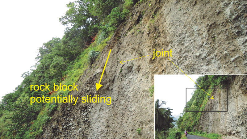
Figure 5: Stowe area, Dominica. Potentially sliding rock blocks due to formation of joints (photo Arnoldus, 2014).
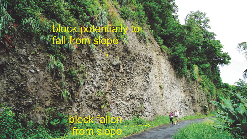
Figure 6. Stowe area, Dominica. Potentially falling rock blocks due to weathering and erosion (photo Arnoldus, 2014).
Soufrière, St Lucia - Flooding
The town of Soufrière, St Lucia is directly above seawater level. The topography rises gradually land inwards. Adjacent to the sea front the ground level is at some locations raised by about 1 m (Figure 7). Seawater, waves, and spray will be flooding or creating nuisance for the town during high water. During a hurricane the town is at severe risk for flooding. Mitigation measures could be many, but often will damage the scenic view of the town. Especially dikes or barriers and high seawalls will change the view on the town apart from being expensive. A movable barrier may be a better and cheaper solution. Such a barrier could consist of a system of concrete or wooden piles with concrete or wooden beams in-between. Holes in the ground for the piles should be made in advance. When high water is imminent, the piles are inserted in the holes and the beams are placed in-between the piles.
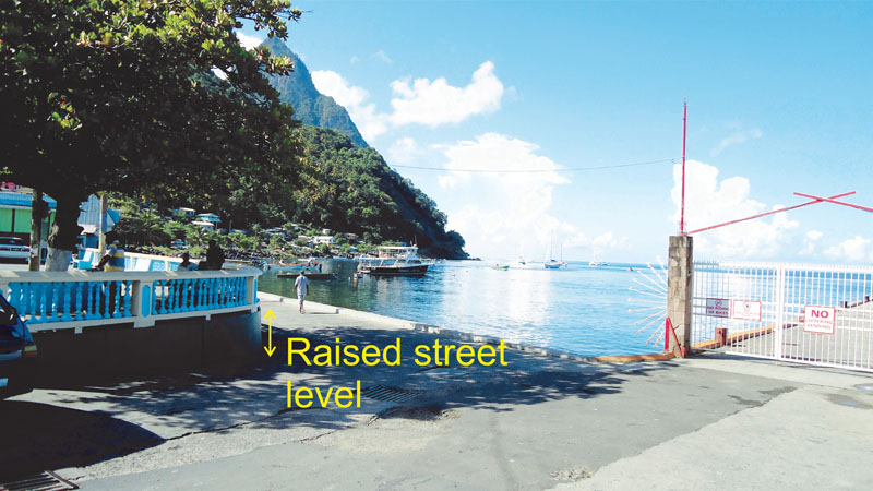
Figure 7: Soufrière, St Lucia. The street level is raised by about 1 m (photo Arnoldus, 2014).
Analysis Steps
The above analysis steps apply equally to both new road planning and the redevelopment of existing roads, although for redevelopment, mitigation options may be more limited.
1. Visual inspection and reconnaissance (typically the responsibility of a Highway Engineer)
A site should be visually inspected on topography, sea and river water levels, geology, quantity of rain and surface water (flash floods, evidence of sea or river flooding, drainage, quantity of sediment transported), the quality of existing roads if any, intensity of traffic, and slope stability on various scales.
Actions to be taken (by Highway Engineer):
- Site visit
2. Determine the necessity of further measures (typically the responsibility of a Highway Engineer)
Actions to be taken (by Highway Engineer):
Flash floods & sediment in flash floods
- Obtain river and sea level, and wave height data from actual detailed measured data, or by questioning local residents of the area. Estimate influence of spray (see above).
- Inspect local structures, e.g. housing and roads, on evidence of damage due to flooding, presence of water, wave action and spray, pavement degradation, i.e. cracks, crack patterns, potholes, and side erosion, and locations of extruding groundwater, due to too high groundwater levels.
- Determine whether road level is situated sufficiently above river or sea level taking into account wave action and spray influence. Preferably wave water coming onto the road should be none or very minimum, and spray water should be such that it can easily be dispersed via the drainage. All measures should be directed towards avoiding the occurrence of buoyancy and excess pore water pressure in the road pavement or base of the road (see before). If the road is not suitably high above sea level, then determine whether increasing height of embankment of the road will solve the wave and spray water problems.
- Determine whether installing river or sea walls would be required to reduce flooding and/or influence of wave action and spray.
- Determine whether existing drainage is sufficient, new artificial drainage should be constructed, or existing artificial drainage should be renovated and, if necessary, be enlarged (for surface run-off water it is advised to read use cases 3.2.2. Roads in flood affected areas and 3.3.3 Landslide mitigation measures for roads).
- Determine whether pavement is sufficient impermeable, and if not, a new surface layer is required. The permeability of the pavement can be estimated visually (studied engineering guess) by the highway engineer or alternatively, tests can be performed following standards (see Methodology Book).
- Estimate (studied or engineering guess) the quantity of sediment in flash floods, run-off water, and deposited by sea waves. Measuring quantities of sediment is virtually no option; visual inspection of the quantity of sediment on the road and in drainage ditches after heavy rainfall (for sediment in surface run-off water), after a flooding (sediment in river water), or storm with high wave heights (for sediment deposited by sea waves) is mostly more effective. Take appropriate measures as detailed in use cases 3.2.3 Roads in landslide affected areas and use case 3.3.3 Landslide mitigation measures for roads for sediment deposited by surface run-off water. Increase height of road above river or sea level, or built protection walls to avoid sediment deposition on the road by river or sea.
Natural slopes, man-induced slope instability, and road cuts
- Inspect topography on steepness, evidence of subsurface displacements indicating landslides and slope instability, i.e. steps in landscape, escarpments and scarps, based on visual inspection, available satellite and aerial imagery, and topographical and geomorphological maps. Question local residents on evidence of (recent) subsurface displacements.
- Determine the ground- and surface water regime.
- Inspect local housing, roads, and other structures on cracks or deformation (i.e. differential settlement and rotation) that may indicate movements in the subsurface.
Actions to be taken (by Highway Engineer with assistance of geotechnical specialist):
- Check local geology and geotechnical data with available geological, geotechnical, and geomorphological maps. If existing maps are not suitable (outdated, insufficient scale or accuracy, or otherwise not suitable) sketch a new geological/geotechnical map on an appropriate scale for the project, on top of satellite or aerial imagery.
- Define the geotechnical units in the subsurface in the area. Geotechnical units are units in which the geotechnical properties are more or less homogeneous, including weathering and discontinuity properties.
- Determine subsurface boundaries between the different geotechnical units based on a priori knowledge on the geology of the area, boreholes, penetration testing, trial pits, etc.
- Determine properties of the geotechnical units based on surface exposures, borehole and penetration test data, groundwater levels, and laboratory test data, and on the data obtained from the points above such as visual inspection and cracks in existing structures.
- Determine future properties of the materials in the geotechnical units. Volcanic materials are often prone to very rapid weathering such as forming of clay minerals which may reduce permeability of materials.
- Built a three-dimensional subsurface model including the geotechnical units with properties. A three-dimensional model may be made in computer model, but can also consist of a series of long- and cross-sections of the subsurface.
- Design and calculate stability of road cuts based on the model of the step before. Take into account the possible future degradation of geotechnical properties due to weathering. Pay special attention to the influence in degradation of the ground due to salt from seawater waves or spray.
Conclusions:
Protection of roads against river and sea water flooding and influence of (sea-) water may require measures from relatively simple and cheap means such as making a dike with available ground from the surroundings, to more sophisticated and expensive dikes and reinforced concrete walls, such as tetrapot dikes. The influence of water and salt in degradation may cause a rapid degradation of natural and man-made materials (e.g. concrete) and thus maintenance should be applied regularly. Slope stability and stability of road cut problems are similar to those described in the use cases on landslides and road cuts.
References:
ASTM International, 2013. ASTM International (formerly American Society for Testing and Materials). West Conshohocken, PA, USA. http://www.astm.org/ [Accessed: 12 November 2013]
Christian, M.D., 2012. A geological outlook on geothermal explorations in Dominica. Geo-Heat Center Quarterly Bulletin. 31 (2). pp. 18-22.
ISO, 2013. International Organization for Standardization (ISO). Geneva, Switzerland. http://www.iso.org/ [Accessed: 14 November 2013]
Lindsay, J., David, J., Shepherd, J. & Ephraim, J., 2002. Volcanic Hazard Assessment for St. Lucia,Lesser Antilles. Seismic Research Unit, The University of the West Indies, St. Augustine, Trinidad and Tobago; Report Presented to the Government of St. Lucia (unpublished), St. Lucia. p. 46
Newman, W.R., 1965. A Report on General and Economic Geological Studies St. Lucia, West Indies. United Nations Programme of Technical Assistance; report prepared for the Government of St. Lucia. Unpublished, St. Lucia
OAS, 1984. St. Lucia Geology Map, Organization of American States (OAS). In: St. Lucia Development Atlas (1987). Modified by The University of the West Indies. University of the West Indies, Seismic Research Centre. http://www.uwiseismic.com/General.aspx?id=72 [Accessed: 7 January 2016]
Roobol, M.J. & Smith, A.L., 2004. Geologic map of Dominica, West Indies. Geology Dept., University of Puerto Rico, Mayagüez, Puerto Rico. http://caribbeanvolcanoes.com/dominica-map/ [Accessed: 9 December 2014]
Smith, A.L., Roobol, M.J. & Gunn, B.M., 1980. The lesser antilles — A discussion of the Island arc magmatism. Bulletin Volcanologique. 43 (2). DOI: 10.1007/BF02598033. ISSN: 0366-483x. pp. 287-302.
Smith, A.L., Roobol, M.J., Mattioli, G.S., Fryxell, J.E., Daly, G.E. & Fernandez, L.A., 2013. The Volcanic Geology of the Mid-Arc Island of Dominica, Lesser Antilles—The Surface Expression of an Island-Arc Batholith. Geological Society of America Special Papers (GSA) Special Papers 496, 2013. DOI: 10.1130/9780813724966. ISSN: 978-0-8137-2496-6. p. 249.
Last update:
06-07-2016