Information Notes

CDEMA Information Note #4 - Hurricane Dorian as of 5:00PM (AST) on August 31st, 2019

CDEMA Information Note #4 - Hurricane Dorian as of 5:00PM (AST) on August 31st, 2019

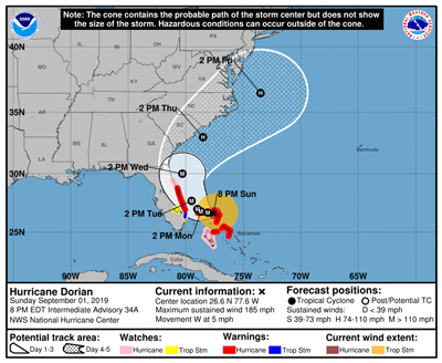
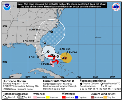
According to the National Hurricane Center (NHC) in Miami, Florida, as of 5:00 PM (AST) on August 31, 2019, the eye of Hurricane Dorian was located near latitude 26.2 North, longitude 74.4 West. Dorian is moving toward the west near 8 mph (13 km/h) and a slower westward motion should continue over the next day or two followed by a gradual turn to the northwest. On this track, the core of Dorian should move near or over portions of the northwestern Bahamas on Sunday September 1, 2019.

Maximum sustained winds are near 150 mph (240 km/h) with higher gusts. Dorian is a category 4 hurricane on the Saffir-Simpson Hurricane Wind Scale. Hurricane-force winds extend outward up to 30 miles (45 km) from the centre. Tropical-storm-force winds extend outward up to 105 miles (165 km).

For full situation report please click here.

CDEMA Information Note #5 - Hurricane Dorian as of 8:00PM (AST) on September 1st, 2019

CDEMA Information Note #5 - Hurricane Dorian as of 8:00PM (AST) on September 1st, 2019

According to the National Hurricane Center (NHC) in Miami, Florida, at 8:00 PM AST, the distinct eye of Hurricane Dorian was located near latitude 26.6 North, longitude 77.6 West. Dorian is moving toward the west near 5 mph (7 km/h). A slower westward to west-northwestward motion is forecast during the next day or two, followed by a gradual turn toward the northwest. On this track, the core of extremely dangerous Hurricane Dorian will continue to pound Great Abaco and Grand Bahama Islands tonight and Monday.

Maximum sustained winds remain near 185 mph (295 km/h) with higher gusts. Dorian is a category 5 hurricane on the Saffir-Simpson Hurricane Wind Scale. Some fluctuations in intensity are likely, and Dorian is expected to remain a catastrophic hurricane during the next few days.

For full situation report please click here.

CDEMA Information Note #1 - Hurricane Jerry as of 5:00PM (AST) on September 19th, 2019

CDEMA Information Note #1 - Hurricane Jerry as of 5:00PM (AST) on September 19th, 2019

National Hurricane Center (NHC) Update

According to the National Hurricane Center (NHC) in Miami, Florida, as at 5:00 PM AST, the eye of Hurricane Jerry was located near latitude 17.5 North, longitude 55.8 West. Jerry is moving toward the west-northwest near 17 mph (28 km/h). A west- northwest to northwest motion at a decreasing forward speed is expected over the next few days. On the forecast track, the center of Jerry will move north of the northern Leeward Islands Friday and pass well north of Puerto Rico on Saturday and be well east-northeast of the southwestern Bahamas on Sunday.

CDEMA Information Note #2 - Tropical Storm Jerry as of 5:00PM (AST) on September 21st, 2019

CDEMA Information Note #2 - Tropical Storm Jerry as of 5:00PM (AST) on September 21st, 2019

National Hurricane Center (NHC) Update

According to the National Hurricane Center (NHC) in Miami, Florida, as at 5:00 PM AST, the eye of Hurricane Jerry was located near latitude 23.0 N 65.8 W. Jerry is moving toward the northwest near 14 mph (22km/h), and this general motion is expected to continue today. Jerry is forecast to turn northward on Sunday and then gradually accelerate northeastward early next week. Maximum sustained winds have increased to near 65 mph (100 km/h) with higher gusts. Little overall change in strength is forecast for the next several days, but short-term fluctuations in intensity are possible. Tropical-stormforce winds extend outward up to 80miles (130 km) from the center.

main-menu