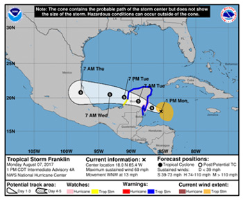
CDEMA Information Note #1 - Tropical Storm Franklin - as of 5:00pm on August 7th, 2017
MESSAGE: The government of Belize has issued a Tropical Storm Warning for the northern portions of Belize as Tropical Storm (TS) Franklin gradually strengthens.
THE SITUATION:
According to the latest public advisory issued by the National Hurricane Center in Miami, Florida, as at 1:00pm (CDT), TS Franklin was located near latitude 18.0N and longitude 85.4W, which places it about 185 miles east of Belize City. TS Franklin is moving toward the west-northwest near 13 mph (20km/h), and this general motion is expected to continue over the next 48 hours. On the forecast track, the center of Franklin will be near the east coast of the Yucatan Peninsula by this evening. Franklin is then expected to move across the Yucatan Peninsula tonight and on Tuesday.
Maximum sustained winds are 60 mph (95 km/h) with higher gusts. Strengthening is forecast until the center reaches the east coast of the Yucatan Peninsula, and Franklin could be near hurricane strength by the time landfall occurs this evening or tonight.
Some weakening is likely while the system across the Yucatan Peninsula on Tuesday.
Tropical storm force winds extend outward up to 140 miles (220 km) from the center. The estimated minimum central pressure is 999 mb (29.50 inches).
Caribbean Institute for Meteorology and Hydrology (CIMH) Weather Briefing
On Monday August 7, 2017, the Caribbean Institute for Meteorology and Hydrology (CIMH) alerted CDEMA via a Weather Briefing on the status of TS Franklin and highlighted the following:
- Franklin is expected to pass just north of the Belize tonight and across the Yucatan Peninsula tonight and on Tuesday. Hurricane conditions are possible before landfall resulting in possible sustained wind speeds exceeding 74 mph with higher gusts.
- Maximum significant wave heights of approx. 4.5 m possible north of Belize City resulting in rough seas. Marine operators and small craft owners should exercise caution and secure property.
- Rainfall accumulations exceeding 4 inches likely with the possibility of localised enhancement due to topography should bands extend to central elevated areas resulting in periods of intense rainfall leading flash flooding and inundation.
- Possible impact to agricultural production in the north of Belize due to strong winds and extreme rainfall
It should be noted that CIMH is not a forecasting agency but provides these briefings to the CDEMA CU to facilitate scenario planning at the regional and national levels.
Tropical Storm Warning Issued
The Government of Belize has issued a Tropical Storm warning for the northern portions of Belize today, Monday August 7, 2017.
A Tropical Storm warning means that tropical storm conditions are expected somewhere within the warning area, in this case within 24 hours.
Regional Actions
The CDEMA Coordinating Unit contacted the National Emergency Management Office (NEMO) in Belize.
The Regional Coordination Plan has been activated and the Regional Response Mechanism has been placed on standby. The CARICOM Disaster and Assessment Coordination (CDAC) Team as well as the CARICOM Operational Support Team (COST) have been placed on alert. The Regional Security System (RSS) has been contacted to place the CARICOM Disaster Relief Unit (CDRU) on standby.
CDEMA will continue to monitor the system and provide updates as is necessary.
CONTACT DETAILS: The CDEMA CU 24-hour contact number 1(246) 434-4880

