Summary
The 2014-2024 Comprehensive Disaster Management (CDM) Strategy and Results Framework of CDEMA highlights the importance of evidence driven decision making, and the need for robust ICT infrastructures to facilitate data sharing. Key to disaster preparedness and response is the availability of authoritative geospatial data.
As part of the first iteration of the CHaRIM project in 2014, a Web GIS platform (based on GeoNode) was established to disseminate the geo-spatial data and value-added map products. Similar platforms were also established in Belize, Saint Lucia, Dominica, Grenada, and St. Vincent and the Grenadines. The ownership of the CHaRIM GeoNode was transferred to CDEMA in 2016. The intention was to facilitate data and knowledge sharing in the region.
Many lessons were learned from these efforts. The use cases presented summarize local, regional, and global efforts towards facilitating the web-based exchange of geospatial data required for CDM.
Use case intended for:
Spatial analyst
Keywords:
HDX, Data Sharing
| Before you start: | Use case Location: | Uses GIS data: | Authors: |
|---|---|---|---|
|
An open source spatial data sharing web platform called GeoNode is considered throughout this section. To learn more about GeoNode, the readers are encouraged to visit http://geonode.org/ |
Belize, Dominica, Grenada, St. Lucia, and St. Vincent and the Grenadines |
Yes |
Dr. Manzul Kumar Hazarika and Ramesh De Silva, Adityo Dwijananto, Ma Louisen Roxas |
Introduction
The collection and dissemination of geospatial information is increasingly becoming easier and cheaper due to rapidly advancing technologies such as smartphones and unmanned vehicles, as well as widespread internet access. The pace of technological change in these areas is only accelerating with advances in cloud computing, machine learning, and high-speed satellite internet. When the first CHaRIM project was executed, many countries in the region sought to locally-host geospatial platforms, however most of these platforms are now offline or have moved to cloud platforms. The GeoNode established for the CHaRIM project has remained online since it is hosted by a cloud provider.
Establishing a geospatial platform requires the existence of a set of enabling conditions related to organizational ICT capacity, availability of technology, decision maker engagement, and enabling policies related to data privacy and sharing. Collectively, these can be thought of as a Spatial Data Infrastructure (SDI). An organizational culture around collaboration and sharing also needs to exist. These enabling conditions have been slow to emerge in the Caribbean region and thus, geospatial capacity remains low. There is wide acknowledgement across the region of the need for the use of geospatial technologies, particularly for disaster risk management activities. However, no official programme exists at the regional level, and only a few ongoing national initiatives exist, although several countries in the region have pursued efforts to establish some type of spatial data infrastructure.
In addition to open cloud hosted GeoCRIS, a local instance has been set up at the CDEMA Coordinating Unit in Barbados. This allows inter-office sharing of geospatial data and is secured from outside access; allowing the sharing of potentially sensitive datasets in a more secure manner.
In the use cases in this chapter, the focus will be on how GeoNode integrates into the GeoCRIS platform, and how the Humanitarian Data Exchange (HDX) platform can be utilized by GeoCRIS, as well as to see how much humanitarian data for the Caribbean islands is shared in HDX. The goal of HDX is to make humanitarian data easy to find and use for analysis by collecting and centralizing data from various parties, including governments, educational institutions, international NGOs, and private companies involved in disaster response.. As an example, the number of humanitarian data related to Dominica was checked in HDX. It was determined that there are approximately 82 datasets shared in the HDX related to Dominica, from population dataset, agriculture, social economy, and infrastructure (such as buildings and roads data from OpenStreetMap).
Objectives:
To provide an overview of geospatial data sharing platforms utilized in the region.
Spatial Data Infrastructure (SDI) Readiness Assessment:
In order to maximize the benefits of an online data sharing platform, it is required to have a well-planned, organized, and carefully coordinated framework. This framework can take the form of an SDI which is defined as, “a framework of policies, institutional arrangements, technologies, data, and people that enables the sharing and effective usage of geographic information by standardizing formats and protocols for access and interoperability”. Successful implementation of digital geospatial initiatives also requires the existence of several enabling technologies and policies, which taken together, form an SDI. Spatial data is special in a way that it has particular standards and data models associated with it, but; like any digital data initiative, it requires the existence of general ICT capacity and data policies in order to function. The existence of these enabling factors can be determined through a readiness assessment. An example of an official method for SDI readiness assessment is the INSPIRE State of Play study which outlines a number of indicators for assessing the maturity of spatial data infrastructure in EU countries. A study of SDI readiness in the Caribbean was completed in 2008 and found that, “the development of SDI and GIS-implementations for sustainable development in the Caribbean happens to be ad hoc and fragmented” . No regional SDI readiness studies have been completed since. However, several Caribbean countries have experimented with SDI programs since the publishing of the assessment in 2008. Jamaica and Belize have passed policies supporting the creation of NSDIs, and Guyana’s National Geospatial Policy is currently undergoing cabinet review. Several Organization of Eastern Caribbean States (OECS) countries are also looking into the development of NSDI through the support of Disaster Vulnerability Reduction Projects (DVRP), as well as Digital Governance Projects. The DVRP in St. Lucia funded a study in 2019, undertaken by Kadastre and KU Leuwen, to assess the readiness of the country to implement
NSDI, along with possible paths to implementation. The study looked in detail at the legal, institutional, and technological requirements for establishing an NSDI. Unfortunately, the COVID-19 pandemic has made the outcome of the NSDI efforts in St. Lucia uncertain. Indeed, many of these SDI efforts, unfortunately, are sidelined due to disasters in the region which shift the focus of decision makers and scarce resources towards initiatives which are seen as more critical.
The NSDI strategy developed for St. Lucia was organized according to the COBIT model (see below). This is, “not a normative standard for organizing a NSDI” but it is a useful way to identify and analyze critical factors for implementing an NSDI. The approach followed in St. Lucia may be applied to other countries in the region as well.
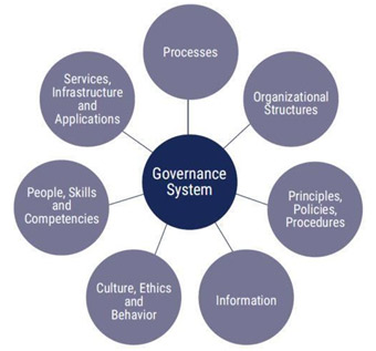
Figure 1. COBIT Model used for the development of NSDI strategy in Saint Lucia
The factors identified and analyzed are as follow:
- Processes
Processes are organised sets of practices and activities. In the context of NSDI, this includes operational processes for collecting, producing and distributing data, and setting requirements for improvements. An assessment of processes may include investigating how data sharing is undertaken, whether it is a systemic or an informal process. Daily business and work processes involving spatial data may also be investigated. - Organisational structures
Organisational structures describe responsibilities, roles, and relationships. An assessment of organization structures may focus on the roles of the operational departments who can be partners within the SDI, and on the role of any coordinating bodies. This type of assessment will identify who are the data producers and consumers within an organization. The assessment will also investigate whether a common vision for SDI currently exists, and if not, whether it can be developed. Existence of effective and dedicated leadership also needs to be investigated. Roles and responsibilities need to be clearly defined, along with the enabling budgets and mandates. - Principles, policies, procedures
Principles, policies, and procedures are the vehicle to translate the desired behaviour into practical guides for day-to-day management. This includes laws, regulations, and policies. This part of the assessment looks at the legal situation around the establishment of NSDI. Do laws governing intellectual property, privacy, access to information, and other aspects critical to data management exist? In the St Lucia assessment, policies and laws were grouped in the following categories:
➔ Promotion
Regulations and policies that promote the availability of key geospatial datasets to all stakeholders.
➔ Limitation
The regulations and policies that limit the availability and/or usage of geospatial information.
➔ Cooperation
The regulations and policies that cover the underlying relationships between stakeholders in the context of NSDI, such as Cooperation/Collaboration, Competition, and Ethics.
➔ Other
The remaining ‘Other’ regulations and policies that (could) have an impact on the SDI i.e., Digitalisation, E-Government, National Services, Licensing, Land Surveying. Land Registry, and Physical Planning Acts.
- Information
The information aspect of the COBIT model describes the data content and its attributes. This part of an assessment usually involves the creation of a spatial data inventory identifying existing datasets and data consumers/producers.
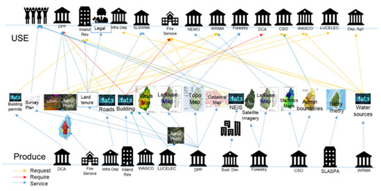
Figure 2. Example Spatial Data Inventory
● Core datasets
Especially important is identifying the core datasets that would form the basis of NSDI. For Disaster Risk Management purposes, these core datasets are classified as Common Operational Datasets (CODs) and Fundamental Operational Datasets (FODs). In developing GeoCRIS, CODs and FODs were identified. The following table shows the CODs identified by CDEMA.
Table 1. Common Operational Datasets identified by CDEMA.
| ADM0 |
| ADM1 |
| ADM2 |
| ADM3 |
| P-Codes |
| Population (associated with Settlement) |
| Population (associated with Admin Boundaries) |
| Roads |
| Airports |
| Ports |
| Contours |
| Hydrology (polylines) |
| Hydrology (point) |
| Hydrology ( polygons) |
| Hospitals |
| Education |
| Fire Station |
| Police Station |
More generally, UN-GGIM and INSPIRE have both developed lists of datasets which could be considered when building a library of core datasets for NSDI.
- Culture, ethics and behaviour
Culture, ethics, and behaviour of individuals, departments, and organisations are key factors in the successful governance and management of activities. Although they are not easy to manage, they often determine the success or the failure of change processes. Therefore, it is important to be aware of them.
For this type of analysis, focus is placed on the culture, ethics, and behaviour that affect the sharing of data, the conditions required for change, and the strategy to steer the willingness to cooperate between organisations. - People, skills, and competencies
This relates to the Human Resources aspect in the COBIT model. The COBIT model refers to several aspects of skills development (requirements, levels, definitions, and categories) and division of tasks (roles). This section of the assessment investigates the availability of the knowledge and skills crucial for implementing an SDI; such as, software development. The availability and frequency of technical training for staff, and knowledge transfer between agencies may also be assessed. Career incentives and mobility may also be assessed. - Infrastructure
This refers to the appropriateness of the existing ICT infrastructure for implementing an SDI. This may include the existence of a reliable network with sufficient bandwidth, as well as redundant power supplies, and onsite/offsite (and out of country) data backups, etc.. It is important to know whether local infrastructure is appropriate for, and capable of, hosting aspects of an SDI. Cloud options are increasingly being used as a substitute for local infrastructure. The Belize NSDI geoportal, for example, uses ESRI’s ArcGIS Online for hosting. The CHaRIM GeoNode and GeoCRIS are both hosted by cloud providers. However, a mirror of GeoCRIS is also present on CDEMA’s local network.
Use Case I - GeoCRIS Platform:
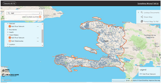
Figure 3. GeoCRIS Web Interface
In the first CHaRIM project, software and technical assistance were provided to Belize, Saint Lucia, St. Vincent and the Grenadines, Grenada, and Dominica towards establishing spatial data sharing platforms based on GeoNode software . The idea at the time was to provide free and open-source software which would provide a catalyst for the development of SDIs, and also encourage regional data sharing and capacity development in open-source geospatial technologies. Belize , Dominica , and Grenada have continued to maintain spatial data sharing platforms, but only Dominica has kept GeoNode as their portal software. GeoNode is a complex, free, and open source software made up of several applications which need to work in sync. The assistance provided to set-up GeoNode was enough to make the GeoNode web applications accessible on the internet, however; long-term support for these platforms never materialized, except in Dominica. Belize has since moved to a solution-based on proprietary ArcGIS software, while Grenada uses GeoServer.
Lessons learned from the previous GeoNode projects were applied in the development of CDEMA’s GeoCRIS platform , which replaces the CHaRIM GeoNode. Consultations were held with CDEMA to ascertain their capacity and needs with regards to GIS. The CHaRIM II team determined that the project will not begin until CDEMA has hired a GIS resource person, as the CHaRIM GeoNode had received no updates or maintenance from CDEMA due to a lack of skilled staff. Once a GIS resource person was hired, they led the coordination with CDEMA’s partners towards the construction of the GeoCRIS, and they received extensive training in the use of the particular applications behind GeoCRIS. This training was also documented in the Standard Operating Procedures (SOPs) and in a Technical Manual specific to the platform and CDEMA’s use cases. The SOPs cover data management aspects such as metadata, quality control and standardization of attribute information, and cartography. All datasets currently on GeoCRIS are intended to pass through the processing steps detailed in the SOPs before upload to GeoCRIS.
Through consultations, the team explored various possibilities for the software which would make up GeoCRIS. The main deciding factor for going with an entirely Free and Open Source Software (FOSS) was the lack of recurring budget at CDEMA for maintaining GIS related software licenses and the limited ICT infrastructure for hosting a platform. The team explored the use of a new version of GeoNode but found that the server resources available would not be sufficient for a performant implementation. Instead, GeoCRIS uses a combination of new and industry standard GIS software, including PostGIS, poycsw, MapServer, Tegola, pg-featureserv, and the MapBox Javascript API (Figure 4). This setup was found to be stable on the server resources available, and has no recurring licensing costs and has lower costs (than GeoNode) for cloud hosting.
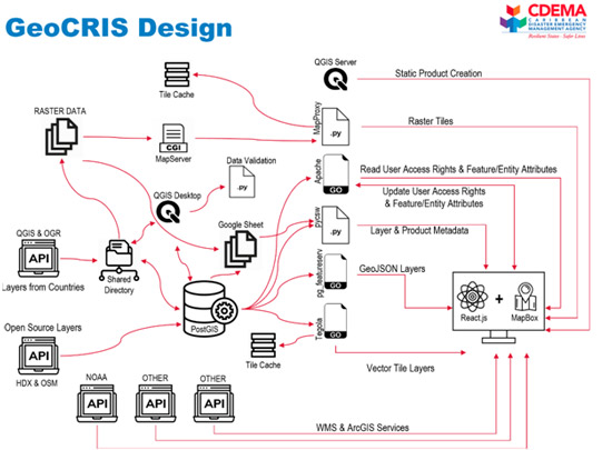
Figure 4. GeoCRIS Architecture Diagram
GeoCRIS is simpler, software wise, than GeoNode, and uses newer technologies; particularly vector tiles, a metadata profile, a server based on ISO19115 but customized to CDEMA’s needs, and the new Open Geospatial Consortium Features API. The social and content management features in GeoCRIS no longer exist as well, although these features can be added later, as required. Past experiences have shown little actual interest in data sharing using GeoNode even though the capability was available and persons were trained. Instead, trained data custodians at CDEMA add data into the system, as requested.
Since content and identity management are not part of GeoCRIS, all of the data served on the web interface is open data. Linkages have been set up between GeoCRIS and major open geospatial data platforms, namely; OpenStreetMap and the Humanitarian Data Exchange (HDX). The Humanitarian Data Exchange (HDX) is a global platform maintained by UN-OCHA, and is widely used by governments, international NGOs, educational institutions, and private companies for sharing any information related to humanitarian data. Data from these platforms is to be ingested automatically into the GeoCRIS database; however, CDEMA has chosen to curate the ingested data before publishing to the open GeoCRIS. In the future, it is hoped that CDEMA will set-up data sharing relationships with it’s partner states; allowing a two-way exchange of information benefiting GeoCRIS. For the moment however, the CHaRIM GeoNode database and the open data platforms are the primary sources of geospatial data on GeoCRIS.
Use Case II – Humanitarian Data Exchange (HDX):
Now that you know the benefits and examples of localized platforms (i.e. platforms that are place-specific in terms of covered service areas just like GeoCRIS) for data sharing, we introduce an alternative global (or non-localized) platform called the Humanitarian Data Exchange (HDX), which is an open platform for sharing humanitarian data (i.e. data about the context in which a crisis is occurring, data about the people affected by the crisis and their needs, and data about the response of organizations and people seeking to help those in need of assistance ) across crises and organizations. Launched in July 2014, the goal of HDX is to make humanitarian data easy to find and use for analysis. HDX works to collect and centralize data from various parties, both from the government, educational institutions, international NGOs, or from private companies involved in disaster response. This allows actors to access and share data outside of their typical operating networks. For example, while data may be readily shared between country-led responders in the Caribbean islands, access to additional data from international NGOs and educational institutions may not typically be accessible to responders, especially in times of disaster response.
HDX has three elements that will eventually combine into an integrated data platform.
- A dataset repository where data providers can upload their raw data spreadsheets and spatial data files for others to find and use.
- A refined database of high-value data - the Common Humanitarian Dataset - that can be compared across countries and crises.
- Standards for how data is described and shared across a network of actors
The data contained in HDX is free to be used by anyone, whether it is the community, the government, or Non Governments Organizations (NGOs). Downloading the data contained in HDX is free and does not need registration, however, to be able to upload data, a contributor must t first join an organization which will then be verified by HDX. Organizations can range from legal entities such as the World Food Programme (WFP) to informal groups such as country-specific working groups. HDX takes this necessary step of verifying organizations to ensure that the organizations and the data they will upload can be trusted and relevant to share with the HDX user community, and that the data being uploaded have the same standards as other countries.
Below is one example of how HDX data is related to the COVID-19 disaster response:
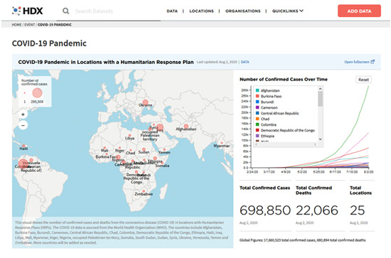
Figure 5. COVID-19 Pandemic Event Page on the HDX website
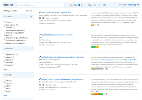
Figure 6. List of data related to the COVID-19 pandemic event
In figure 6, it can be seen that the data uploaded related to the COVID-19 disaster response came from various sectors, ranging from universities, international NGOs, governments, and the private sector. Such datasets are certainly very useful for all aspects involved in the COVID-19 disaster response.
A significant amount of data for the Caribbean region is already available on HDX, especially for social datasets such as the latest population data, namely High Resolution Settlement Layer Population Data. For example, when looking at the search results for Belize,HDX shows that there are approximately 60 types of data available, as shown in Figure 7 below:
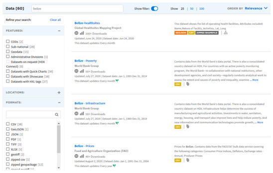
Figure 7.The dataset for Belize that is available on the HDX platform.
Another example is the datasets for Dominica. In HDX, we can find approximately 82 datasets for Dominica uploaded by several international organizations such as the Humanitarian OpenStreetMap Team (HOT) and the World Bank Group. The datasets available for this country vary from tabular data to spatial data such as population data uploaded by Facebook and WorldPop. The datasets uploaded to HDX will certainly be very helpful for anyone looking to use the data for analysis.
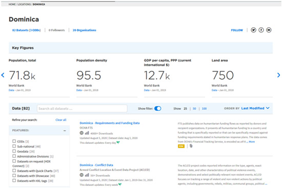
Figure 8. The dataset for Dominica that is available on the HDX platform.
It is recommended to explore the various datasets available for different countries in HDX. For datasets that can potentially be shared through the HDX platform, note that you must register under an organization that can be verified by HDX before being allowed to upload datasets. Joining HDX has several benefits such as:
- Ability to contact data contributors to ask about their uploaded data,
- Joining an organization to get access to more private data, which matches your role in the organization,
- Creating a new organization that, when verified by HDX, can start to upload public and private data, and;
- Making a visualization or showcase related to the data uploaded.
Conclusions:
GeoNode is a simple but powerful platform to share and publish geospatial data. GeoNode has been established at five pilot countries in the Caribbean region namely, Belize, Dominica, Grenada, St. Lucia and St. Vincent and the Grenadines, but factors such as infrastructures, resources, capacities, and coordination among the stakeholders will ultimately determine their sustainability. If the pilot countries can meet these challenges, then GeoNode can facilitate a robust geospatial data sharing platform for implementing multi-disciplinary projects such as multi-hazard risk assessment and management, which can help in informed decision making. A common GeoNode has also been implemented remotely to share geospatial data until the pilot countries reach a level where they can maintain their own GeoNodes.
GeoCRIS ,on the other hand, is the geospatial component of the Caribbean Risk Information System that complements the virtual library and databases of CDEMA. GeoCRIS integrates GeoNode and OpenStreetMap into its platform to encourage collaborative geospatial data sharing and use among the Caribbean countries. Also, since content and identity management are not part of GeoCRIS, all of the data that will be served on the web interface is open data derived from OpenStreetMap and the Humanitarian Data Exchange. Datasets from these platforms will also be automatically ingested by the GeoCRIS database following the curation of data done by CDEMA.
Humanitarian Data Exchange (HDX) is a good alternative for sharing and accessing data. . The Humanitarian Data Exchange (HDX) is an open platform for sharing data across crises and organizations. HDX provides a variety of data ranging from tabular data (CSV, Excel, etc) to spatial data such as shapefiles, geopackage, geojson, etc. The data uploaded into HDX has been through a strict screening process by the HDX, and has no element of personally identifiable information (PII). In addition, the data available on HDX are free and open, meaning any user can freely download available datasets on HDX. However, to be able to upload data on HDX, an account that is entered into a particular organization is needed.
With the combination of GeoNode and HDX, surely a cross-country and cross-organizational collaboration can be realized to help support disaster risk reduction analysis.
Last update: 27-01 - 2021