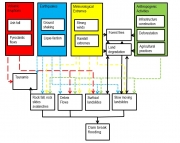
One of the difficult issues in natural hazards risk assessment is how to analyze the risk for more than one hazard in the same area, and the way they interact. Figure 1 shows an illustration of how different sets- of triggering factors can cause a number of different hazards. There are many factors that contribute to the occurrence of hazardous phenomena, which are either related to the environmental setting (topography, geomorphology, geology, soils etc.) or to anthropogenic activities (e.g. deforestation, road construction, tourism). Although these factors contribute to the occurrence of the hazardous phenomena and therefore should be taken into account in the hazard and risk assessment, they are not directly triggering the events. For these we need triggering phenomena, which can be of meteorological or geophysical origin (earthquakes, or volcanic eruptions). A generally accepted definition of multi-hazard still does not exist. In practice, this term is often used to indicate all relevant hazards that are present in a specific area, while in the scientific context it frequently refers to “more than one hazard”. Likewise, the terminology that is used to indicate the relations between hazards is unclear. Many authors speak of interactions (Tarvainen et al. 2006, de Pippo et al. 2008, Marzocchi et al. 2009, Zuccaro and Leone 2011, European Comission 2011), while others call them chains (Shi 2002), cascades (Delmonaco et al. 2006a, Carpignano et al. 2009, Zuccaro and Leone 2011, European Comission 2011), domino effects (Luino 2005, Delmonaco et al. 2006a, Perles Roselló and Cantarero Prados 2010, van Westen 2010, European Comission 2011), compound hazards (Alexander 2001) or coupled events (Marzocchi et al. 2009).
Figure 1: Illustration of multi-hazards, caused by different triggering factors, and the often complex relations between the individual hazards
Compared to single processes, standard approaches and methodological frameworks for multi-hazard risk assessment are less common in the literature (Kappes et al., 2012), which is related to the complex nature of the interaction between the hazards, and the difficulty to quantify these.
Independent events
The simplest approach is to consider that the hazards are independent and caused by different triggers. If that is the case the risk can be calculated by adding the average annual losses for the different types of hazard. This would be the case for example for earthquake hazard and flood hazard. They have different triggering mechanisms which do not directly interact. Therefore earthquake hazard is independent of flood hazard and may be analyzed separately. Also the risk may be analyzed separately and the resulting losses could be added. Other examples of independent hazard are for instance technological hazards and flood hazards. Many of the existing software tools for multi-hazard risk assessment (See below) deal with these hazard independently, and sum up the losses. However, when we examine these apparent inexpediences in detail, the relation may be more complicated. for instance an earthquake may trigger landslides that may block a river leading to flooding, which makes that the earthquake and flood risk cannot be considered entirely independent. Event flooding and technological hazards cannot be considered completely independent: during low levels of flooding traffic can still pass, but has a higher risk of accidents.
Coupled events
The second multi-hazard relationship is therefore between different hazard types that are triggered by the same triggering event. These are what we would call coupled events (Marzocchi et al., 2009). The temporal probability of occurrence of such coupled events is the same as it is linked to the probability of occurrence of the triggering mechanism. For analyzing the spatial extent of the hazard, one should take into account that when such coupled events occur in the same area and the hazard footprints overlap, the processes will interact, and therefore the hazard modeling for these events should be done simultaneously, which is still very complicated. In order to assess the risk for these multi-hazards, the consequence modeling should therefore be done using the combined hazard footprint areas, but differentiating between the intensities of the various types of hazards and using different vulnerability-intensity relationships. When the hazard analyses are carried out separately, the consequences of the modeled scenarios cannot be simply added up, as the intensity of combined hazards may be higher than the sum of both or the same areas might be affected by both hazard types, leading to overrepresentation of the losses, and double counting. Examples of such types of coupled events is the effect of an earthquake on a snow-covered building (Lee & Rosowsky, 2006) and the triggering of landslides by earthquakes occurring simultaneously with ground shaking and liquefaction (Delmonaco et al. 2006b, Marzocchi et al. 2009). Within multi-hazard risk assessment the best way to treat coupled risk is to take the maximum of the risks that are coupled. for example, during the same tropical storm a village may be hit by flash floods or debris flows. Once it is hit by one type there is damage, and buildings cannot be destroyed twice during the same event.
One hazard changes conditions for the next
A third type of interrelations is the influence one hazard exerts on the disposition of a second hazard, though without triggering it (Kappes et al. 2010). An example is the "fire-flood cycle" (Cannon & De Graff, 2009): forest fires alter the susceptibility to debris flows and flash floods due to their effect on the vegetation and soil properties. This problem highlights the fact that the conditions that make certain areas more susceptible to hazards may change constantly. For instance land cover and land use have a large effect on hydro-meteorological hazards such as flooding and landslides. When these change as a result of other hazards (like forest fires), also the susceptibility to landslides, debrisflows or floods increases. Many of the hazard relations are of this type. For instance, volcanic eruptions may lead to the deposition of volcanic ash, which will increase the susceptibility to landslides and flooding. Earthquakes may trigger landslides, and the landslide scars that are unvegetated may lead to increased erosion and debrisflows. It is very difficult to take this type of relationship into account before one particular hazard has changed the conditions that make the terrain more susceptible to the second hazard. The practice is to update a multi-hazard risk assessment each time after the occurrence of a major hazard event (like a volcanic eruption, major earthquake or hurricane).
Domino or cascading hazards
The third type of hazard relationships consists of those that occur in chains: one hazard causes the next. These are also called domino effects, concatenated, or cascading hazards. These are the most problematic types to analyze in a multi-hazard risk assessment. Hazard may occur in sequence, where one hazard may trigger the next. These hazard chains or domino effects are extremely difficult to quantify over certain areas, although good results have been obtained at a local level (e.g Peila and Guardini, 2008).
The best approach for analyzing such hazard chains is to use so-called event-trees. An event tree is a system which is applied to analyze all the combinations (and the associated probability of occurrence) of the parameters that affect the system under analysis. All the analyzed events are linked to each other by means of nodes all possible states of the system are considered at each node and each state (branch of the event tree) is characterized by a defined value of probability of occurrence.
Example of multi-hazard chain: Layou Valley landslides in Dominica
The Layou-Carholm Landslides represent a complex series of landslides that achieved climactic proportions in 1997 and 2011 remains a hazard today. The Layou River, with a length of 17 km is one of the largest watersheds in Dominica (70 km2) and drains about 9% of the land (ACOE, 2004). The Layou Tuff forms vertical walls along the lower Matthieu and Layou Rivers through these reaches. This welded tuff resulted from ignimbrite eruptions in the Late Pleistocene centered on Morne Couronne (Roobol and Smith, 2004). In addition to the Layou Tuff, both, 1.8-Ma- and 2.0 to 1.8-Ma-year-old block and ash deposits from this eruptive center are the primary bedrock present throughout the drainage basins for these two rivers (Roobol and Smith, 2004).
Landslides were common in the area, with specific reports occurring between 1987 and 1997. There is an eyewitness account of a slide following Hurricane Hugo in 1989 and also following Hurricanes Iris, Luis and Marilyn in 1995. There was a major change to the pattern of small landslides. Dramatic slumping occurred between November 18 and 25, 1997. Two major slides blocked the river and created a natural dam. The dam was breached on November 21 with mudflows reaching the sea accompanied by extensive flooding of the lower river valley. The larger of the Layou flood events on November 28, 1997, measured 1,325,000 m3. A wall of material estimated at 50 feet high was washed downstream. The riverbed rose dramatically in its lower reaches. This elevation was estimated at 30 feet at the location of the swing bridge. The river had dried up between November 18-20 1997 and then flooded on November 21. Further landslides occurred on November 25, 1997 and October 8 and 11, 1998 with subsequent dam breaks being significant events. End-of-the-year measurements show that the lake depth increased from 22 m in 1998 to nearly 40 m in 2008 (DeGraff et al., 2010). The maximum volume estimate is 3,611,985 m3, assuming failure by overtopping and complete draining of the lake (Breheny, 2007). A major dam break event occurred on 28/06/2011. Heavy rainfall caused breach of the Matthieu Dam that was formed as a result of the Carholme landslide in 1997 and caused a massive flooding in Layou River washing out the Gleau Chaud Bridge and causing destruction to roads. The road along the Layou River to Pont Casse was closed, due to flood hazard.
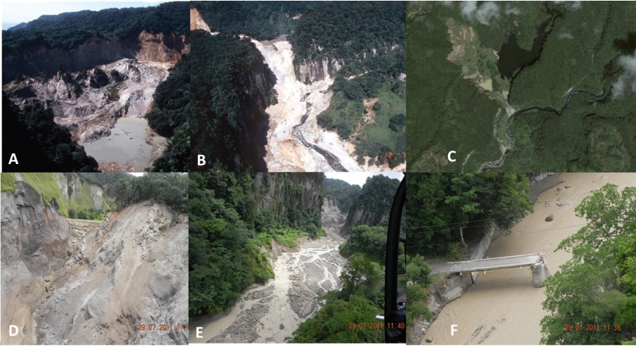
Figure 2: Mathieu landslide dam development. A: Carholm landslide blocking the Mathieu River and forming a lake in 1997 (Photo: J. DeGraff), B: View from downstream along the Layou valley towards the confluence of Layou and Mathieu river, with landslide dam location in 1997 (Photo: DeGraff, 1997); C: Google Earth image 3/8/2005 showing dammed lake. D: landslide dam washed out after dam break in May 2010; E: View from downstream towards former landslide dam, note the large area affected by dam break flooding; F: Bridge destroyed by dam break flood
The table below shows the main multi-hazard relationships for the hazards occurring in the Caribbean countries.
Table 1 : Main hazard types in the Eastern Caribbean and the interactions, as described above. The relationship should be read starting from the left and reading horizontally.
|
|
Earthquake |
Volcanic eruption |
Tsunami |
Storm surge |
River flooding |
Landslides |
Forest fires |
|---|---|---|---|---|---|---|---|
|
Earthquake |
- |
Independent |
Chain |
Independent |
Independent |
Chain |
Independent |
|
Volcanic eruption |
Independent |
- |
Chain |
Independent |
Disposition |
Disposition |
Chain |
|
Tsunami |
Caused by |
Caused by |
- |
Independent |
Independent |
Chain along coast |
Independent |
|
Storm surge |
Independent |
Independent |
Independent |
- |
Chain |
Chain |
Independent |
|
River flooding |
Independent |
Independent |
Independent |
Coupled |
- |
Coupled |
Independent |
|
Landslides |
Caused by |
Independent |
Independent |
Coupled |
Coupled |
- |
|
|
Forest Fires |
Independent |
Coupled |
Independent |
Independent |
Disposition |
Disposition |
- |
Tools for multi-hazard assessment
Risk assessment is computationally intensive. It can be carried out using conventional GIS systems, although it is advisable to use specific software tools. Loss estimation has been carried out in the insurance sector since the late 1980's using geographic information systems. Since the end of the 1980's risk modelling has been developed by private companies resulting in a range of proprietary software models for catastrophe modelling for different types of hazards. Unfortunately these are not publicly available, which is a major obstacle to the development of risk assessment for many parts of the world by government organizations. The best initiative for publicly available loss estimation thus far has been HAZUS developed by the Federal Emergency Management Agency (FEMA) together with the National Institute of Building Sciences (Schneider and Schauer, 2006). The first version of HAZUS was released in 1997 with a seismic loss estimation focus, and was extended to multi-hazard losses in 2004, incorporating also losses from floods and windstorms. HAZUS was developed as a software tool under ArcGIS. Several other countries have adapted the HAZUS methodology to their own situation. The HAZUS methodology has also been the basis for the development of several other software tools for loss estimation. One of these is called SELENA. Also an interesting example is RiskScape developed in New Zealand (Schmidt et al., 2011).
Another interesting development has been going on in the development of standalone software modules for multi-hazard risk assessment, which are not running as a component of an existing GIS. A good example of this is the CAPRA Probabilistic Risk Assessment Program supported by the World Bank (CAPRA, 2013). The methodology focuses on the development of probabilistic hazard assessment modules, for earthquakes, hurricanes, extreme rainfall, and volcanic hazards, and the hazards triggered by them, such as flooding, windstorms, landslides and tsunamis.
Another recent development is towards Open Source web-based modules for multi-hazard risk assessment. A tool which is currently under development as part of the Global Earthquake Initiative (GEM), called OpenQuake, is most probably going to be the standard for earthquake loss estimation, as there are also plans to expand it into a multi-hazard risk assessment tool.
 If you are interested in learning more about risk analysis tools, you can find an overview of a larger number of tools in this document. It is remarkable that there are many more tools for earthquake loss estimation as compared to other hazards. The common aspect of these software programs, is that they are used to analyze damages and replacement costs, casualties, disruption and number of people affected by various hazards. They differ in terms of the methods used for hazard assessment, asset exposure analysis, vulnerability assessment and the method for risk calculation. What they also have in common is that these methods are very data demanding.
References
ACOE (ARMY CORPS OF ENGINEERS), 2004, Water Resources Assessment of Dominica, Antigua, Barbuda, St. Kitts andNevis: Mobile District and Topographic Engineering Center Report, U.S. Army Corps of Engineers, Mobile, AL, 94 p.
Alexander D (2001). Encyclopedia of environmental science, Chapter Natural hazards. Kluwer Academic Publishers
Bedford T, Cooke RM (2001). Probabilistic Risk Analysis: Foundations and methods; Cambridge University Press
Birkmann J (ed) (2006). Measuring Vulnerability to Natural Hazards: Towards Disaster Resilient Societies. UNU Press, Tokyo, New York.
Birkmann J (2007). Risk and vulnerability indicators at different scales: Applicability, usefulness and policy implications. Environmental Hazards 7 (2007) 20–31
Bollin C, Hidajat R (2006). Community-based disaster risk index: pilot implementation in Indonesia. In: Birkmann, J. (Ed.), Measuring Vulnerability to Natural Hazards—Towards Disaster Resilient Societies. UNU-Press, Tokyo, New York, Paris
Breheny, P., 2007, Hydrogeologic/Hydrological Investigation of Landslide Dam and Impounded Lake in the Matthieu River Valley, Commonwealth of Dominica, West Indies: Unpublished M.S. Dissertation, University of Leeds, United Kingdom.
Cannon S and DeGraff J (2009). The increasing wildfire and post-fire debris-flow threat in Western USA, and implications for consequences of climate change. In K Sassa and P Canuti (Eds.) Landslides - disaster risk reduction, Springer Verlag, 177-190
CAPRA (2013). Probabilistic Risk Assessment Program URL http://www.ecapra.org/Carpignano A Golia E Di Mauro C Bouchon S and Nordvik J-P (2009). A methodological approach for the definition of multi-risk maps at regional level: first application. Journal of Risk Research, 12:513–534
Coppock, JT (1995) GIS and natural hazards: an overview from a GIS perspective. In: Carrara A and Guzzetti F (eds) Geographical Information Systems in Assessing Natural Hazards. Volume 5 of the series Advances in Natural and Technological Hazards Research pp 21-34
Corominas J, van Westen CJ, Frattini P, Cascini L, Malet J-P, Fotopoulou S, Catani F, van den Eeckhaut M, Mavrouli O, Agliardi F, Pitilakis K, Winter MG, Pastor M, Ferlisi S, Tofani V, Hervas J, Smith JT (2014) Recommendations for the quantitative analysis of landslide risk : open access. In: Bulletin of engineering geology and the environment IAEG, 73 (2014)2 pp. 209-263
Cova TJ (1999) GIS in emergency management. In Geographical Information Systems: Principles, Techniques, Applications, 2nd Edition: Management Issues and Applications, Edited by: Longley (Eds) P. A.
DeGraff, J.V., 1987a. Landslide hazard on Dominica, West Indies-Final Report. Washington, D.C., Organization of American States.
DeGraff, J.V. 1987b. Geological Reconnaissance of the 1986 landslide activity at Good Hope, D’Leau Gommier, and Belvue Slopes, Commonwealth of Dominica, West Indies, Report submitted to: Commonwealth of Dominica and the OAS
DeGraff, J.V., Bryce, R., Jibson, R.W., Mora, S., and Rogers, C.T., 1989, Landslides: Their extent and significance in the Caribbean, Proceedings of the 28th International Geological Congress: Symposium on Landslides
DeGraff, J.V. 1990a. Post-1987 Landslides on Dominica, West Indies: An Assessment of LandslideHazard Map Reliability and Initial Evaluation of Vegetation Effect on Slope Stability, Submitted to The Commonwealth of Dominica and the OAS
DeGraff, J.V. 1990b, Potential Landslide-Dam Hazard Below Freshwater Lake, Commonwealth of Dominica, West Indies, Report submitted to Commonwealth of Dominica and the OAS
DeGraff, J. V., 1991: Determining the significance of landslide activity: Examples from the Eastern Caribbean. Caribb. Geogr., 3, 31–42.
DeGraff, J. V., 1995, Natural Hazards Vulnerability of the Dominica Hydroelectric Expansion Project: Caribbean Disaster Mitigation Project Final Report, Organization of American States, Washington, DC, 26 p.
DeGraff, J. V., 1997, Technical Assessment of the Landslide-Dam Emergency, Commonwealth of Dominica, W.I.: U.S. Agency for International Development Report, Office of the U.S. Foreign Disaster Assistance, Washington, DC, 24 p.
DeGraff, J.V., James, A. and Breheney, P., 2010. The Formation and Persistence of the Matthieu Landslide-Dam Lake, Dominica, W.I.. Environmental & Engineering Geoscience, Vol. XVI, No. 2, May 2010, pp. 73–89
DeGraff, J.V., Romesburg, H.C., Ahmad, R, and McCalpin, J. 2012. Producing landslide-susceptibility maps for regional planning in data-scarce regions. Nat Hazards (2012) 64:729–749
DeGraff, J. V. and Rogers, C. T., 2003, An unusual landslide dam event in Dominica, West Indies: Landslide News, No. 14/15, pp. 8–11.
DeGraff JV (2012) Solving the dilemma of transforming landslide hazard maps into effective policy and regulations, Nat. Hazards Earth Syst. Sci., 12, 53-60
Delmonaco G Margottini C and Spizzichino D (2006a). ARMONIA methodology for multi-risk assessment and the harmonisation of different natural risk maps. Deliverable 3.1.1, ARMONIA.
Delmonaco G Margottini C and Spizzichino D (2006b). Report on new methodology for multi-risk assessment and the harmonisation of different natural risk maps. Deliverable 3.1, ARMONIA.
de Pippo T Donadio C Pennetta M Petrosino C Terlizzi F and Valente A (2008). Coastal hazard assessment and mapping in Northern Campania, Italy. Geomorphology, 97:451–466.
EC (2011). Risk assessment and mapping guidelines for disaster management. European Commission Commission staff working paper, European Union.
FEMA (2004). HAZUS-MH. FEMA’s Methodology for Estimating Potential Losses from Disasters. US Federal Emergency Management Agency. http://www.fema.gov/plan/prevent/hazus/index.shtmGarcia-Aristizabal A, Marzocchi W (2013). Software for multi-hazard assessment. Deliverable 3.5 of the EU Matrix project: New methodologies for multi-hazard and multi-risk assessment methods for Europe. URL: http://matrix.gpi.kit.edu/downloads/MATRIX-D3.05.pdf.
Granger K, Jones TG, Leiba M, Scott G, (1999).Community risk in Cairns: a multi-hazards risk assessment. Technical report, Australian Geological Survey Organisation (AGSO) URL http://www.ga.gov.au/corporate_data/33548/33548.pdf.
Greiving S, Fleischhauer M, Lückenkötter, J. (2006) A Methodology for an integrated risk assessment of spatially relevant hazards, Journal of Environmental Planning and Management, 49:1, 1-19
Guha-Sapir D, Below R, Hoyois Ph (2016) - EM-DAT: The CRED/OFDA International Disaster Database – www.emdat.be – Université Catholique de Louvain – Brussels – Belgium.
Haimes YY (2009) Risk Modeling, Assessment, and Management. 3rd Edition. John Wiley & Sons, 1009 p
IRDR (2014) Integrated Research on Disaster Risk. Peril Classification and Hazard Glossary (IRDR DATA Publication No. 1). Beijing: Integrated Research on Disaster Risk. http://www.irdrinternational.org/wp-content/uploads/2014/04/IRDR_DATA-Project-Report-No.-1.pdfISO 31000 Risk Management – Principles and guidelines. URL: http://www.iso.org/iso/home/standards/iso31000.htm
Jaboyedoff M, Aye ZC, Derron M-H, Nicolet P, Olyazadeh R. (2014) Using the consequence - frequency matrix to reduce the risk: examples and teaching. International Conference Analysis and Management of Changing Risks for Natural Hazards 18-19 November 2014, Padua, Italy
Jonkman, SN, Van Gelder P, and Vrijling H (2002). An overview of quantitative risk measures and their application for calculation of flood risk. λµ13 - ESREL 2002 European Conference
Kappes MS, Keiler M, Von Elverfeldt K, Glade T, (2012). Challenges of analyzing multi-hazard Risk: A Review. Natural Hazards 64(2), 1925-1958
Lacasse S Eidsvik U Nadim F Hoeg K and Blikra LH (2008). Event tree analysis of Aknes rock slide hazard. IV Geohazards Quebec, 4th Canadian Conf. on Geohazards, 551-557.
Lee K and Rosowsky D (2006). Fragility analysis of woodframe buildings considering combined snow and earthquake loading. Structural Safety, 28: 289-303
Luino F (2005). Sequence of instability processes triggered by heavy rainfall in the northern Italy. Geomorphology, 66:13–39.
Marzocchi W Mastellone M and Di Ruocco A (2009). Principles of multi-risk assessment: interactions amongst natural and man-induced risks. European Commission. URL : http://cordis.europa.eu/documents/documentlibrary/106097581EN6.pdfOAS (1991) Geographic Information Systems In Natural Hazard Management. Organization of American States. Primer on Natural Hazard Management in Integrated Regional Development Planninghttps://www.oas.org/dsd/publications/Unit/oea66e/ch05.htm
Peila D, Guardini C (2008) Use of the event tree to assess the risk reduction obtained from rockfall protection devices. Nat. Hazards Earth Syst. Sci., 8, 1441–1450, 2008
Perles Roselló M and Cantarero Prados F (2010). Problems and challenges in analyzing multiple territorial risks. methodological proposals for multi-hazard mapping. Boletín de la Asociación de Geógrafos Espanoles, 52:399–404
Prinos P (2008). Review of Flood Hazard Mapping. European Community Sixth Framework Programme for European Research and Technological Development. FLOODsite.
Roberts NJ, Nadim F, Kalsnes B (2009). Quantification of vulnerability to natural hazards. Georisk: Assessment and Management of Risk for Engineered Systems and Geohazards, 3 (3), 2009, 164-173
Roobol, M. J. and Smith, A. L., 2004, Geologic Map of Dominica, West Indies: Geology Department, University of Puerto Rico at Mayaguez. Electronic document, available at http://www.caribbeanvolcanoes.com/dominica/content/dominicamap.pdfSchmidt J, Matcham I, Reese S, King A, Bell R, Henderson R, Smart G, Cousins J, Smith W, Heron D, (2011). Quantitative multi-risk analysis for natural hazards: a framework for multi-risk modelling. Natural Hazards 58(3), 1169-1192
Schneider PJ, Schauer BA, (2006). HAZUS‚ its development and its future. Natural Hazards Review 7(2), 40-44.
Shi P Shuai J Chen W and Lu L (2010). Study on the risk assessment and risk transfer mode of large scale disasters. In The 3rd International Disaster and Risk Conference IDRC, Davos, Switzerland
Tarvainen T Jarva J and Greiving S (2006). Spatial pattern of hazards and hazard interactions in Europe. In Schmidt-Thomé, P. (ed), Natural and Technological Hazards and Risks Affecting the Spatial Development of European Regions, 42: 83–91
UN-ISDR (2009). Terminology on Disaster risk Reduction. URL: https://www.unisdr.org/we/inform/terminologyVan Westen CJ, Castellanos Abella EA and Sekhar LK (2008) Spatial data for landslide susceptibility, hazards and vulnerability assessment : an overview. In: Engineering geology, 102 (2008)3-4 pp. 112-131.
Van Westen C J Quan Luna B Vargas Franco R D (2010) Development of training materials on the use of geo - information for multi - hazard risk assessment in a mountainous environment. In: Mountain risks : bringing science to society : proceedings of the Mountain Risks International Conference, Firenze, Italy, 24-26 November 2010 / ed. by J.-P. Malet, T. Glade and N. Casagli. - Strasbourg : CERG, 2010. ISBN 2-95183317-1-5. pp. 469-475.
Van Westen CJ, Straatsma MW, Turdukulov UD, Feringa WF, Sijmons K, Bakhtadze K, Janelidze T, Kheladze N. (2012) Atlas of natural hazards and risks of Georgia : e-book. Tbilisi, Caucasus Environmental NGO Network (CENN), University of Twente Faculty of Geo-Information and Earth Observation (ITC), 2012. ISBN: 978-9941-0-4310-9.
Van Westen CJ (2013). Remote sensing and GIS for natural hazards assessment and disaster risk management. In: Shroder, J. (Editor in Chief), Bishop, M.P. (Ed.), Treatise on Geomorphology. Academic Press, San Diego, CA, vol. 3, Remote Sensing and GIScience in Geomorphology, pp. 259–298.
Zuccaro G and Leone M (2011). Volcanic crisis management and mitigation strategies: a multi-risk framework case study. Earthzine, 4.