This section describes fluvial modeling approaches, and links to the method used for flood modeling in Belize, which is described further in Use Case 8.6.
Keywords:
Fluvial, modeling
|
Author |
Links |
|---|---|
Introduction
Fluvial modeling is the process of simulating the flow of water in a river and its floodplain using a computer program. It is sometimes referred to as river modeling. This modeling process provides predictions of the behavior of the river under different conditions, which can provide information about the river for many useful purposes. For example, a bridge engineer will need to know how high extreme water levels might get in order to build a bridge high enough that it is not damaged by flood waters, and that the bridge does not cause an obstruction to the river, and therefore increase local flood levels. If simulating a flood is of interest, the fluvial model is referred to as a flood model, but fluvial models can also be used to simulate low flow conditions, or the movement of sediments or water quality issues. It is important to bear in mind that a particular fluvial model will often be built for a specific purpose and therefore may not be suitable for other uses directly. The fluvial modeling described in this chapter is not exhaustive, as it is focused on the most applicable for the CHARIM project. For information on other approaches or for more detail on those described here, the reader is referred to the external resource links at the end of the chapter.
Components of a fluvial model
In a very general sense, a fluvial model requires three components: (1) topography (geometry) data of the river and floodplain, (2) water quantity data, and (3) a computer program which calculates the physics of the water flowing over the topography. The person who puts the first three together, i.e. builds the fluvial model, is known as the modeler. There are many possible options and combinations of each of the components, varying in detail and complexity. The actual component choices in building a fluvial model will be driven by the questions that the model is built to answer, the data that is available or can be collected affordably, and finally, the skills of the modeler. Once the model is put together, it is adjusted and tested before being used in a process known as calibration and validation, where the modeler attempts to make sure the model produces answers that are as close to reality as possible by comparing the model with river observations and measurements. However, it is important to remember that all the models, even the best and most expensive ones, are only approximations of reality and therefore will not produce perfect results, but none-the-less can be very useful.
What are fluvial models used for?
Fluvial modeling has many uses. In the following table, a few of the more common ones, likely to be of interest in Belize and the Caribbean, are detailed.
Table 1: Applications of fluvial modeling relevant for Belize and the Caribbean.
|
Application |
Description |
Method comments |
|---|---|---|
|
Flood hazard mapping |
modeling of extreme probability based flood events for the purposes of identifying flood hazard extents (locations) and severity (water levels and velocities). |
This is one of the most common applications of fluvial modeling. For example the National flood hazard mapping undertaken for the CHarim project is a specialised (due to the spatial coverage) example of this - See use case and national report for Belize. |
|
River structure design (e.g. bridges, culverts, flood defences) |
The engineering design of river structures requires detailed parameters (flow, levels and velocities) regarding specific design flows in a river in order to suitably size structures as well as design protection for the structure from more extreme events, as well as physical consequences of river flow, such as river bed scour. |
This application of fluvial models tends to be the most detailed and complex, usually requiring specially commissioned topography surveys and significant experience of engineering design. It is possible to find specialist culvert design software which incorporates simplified elements of hydraulic modeling but these are generally aimed at culvert sizing estimates rather than full structure design (See use case on roads in flood affected areas). |
|
Real time flood warning |
A specialist type of flood modeling, with some flood warning systems requiring models running continually in real time in an attempt to predict near-future (the next hours or days) river levels in order to provide reliable flood warnings. A real time model runs quicker than the event being modelled allowing a prediction before the event reaches its peak. |
This application is one of the hardest to implement as it requires real time telemetry links to river data which is used to continually update the model predictions as well as a fast model running on dedicated, continually operating computer hardware. Pre-running models can be used to build a library of flood events for simpler flood warning systems and this can get around some of the operational complexities and expense of running a model in real time. |
|
Drainage design outlet conditions |
The design and operation of urban land drainage networks usually requires a discharge output to a downstream river. The design conditions for this outlet are often taken from a companion fluvial model of the river to ensure correct drainage function under different flow conditions. |
Drainage design networks require a similar form of hydraulic modeling to the fluvial models of the river, but they are designed for pipes or open concrete channels rather than natural river channels. |
|
Flood Risk Assessments (FRA) and Environmental Impact Assessments (EIA) |
Fluvial models are used in FRAs and EIAs for infrastructure projects to ensure that the environment and other river users are not adversely affected by changes to the river or its surroundings. |
An FRA example of this is the design of mitigation so flood protection structures designed to protect a development do not cause adverse effects for other river users (e.g. displacing flood water to properties downstream). An EIA example might be to ensure sufficient dilution and adequate mixing of treated effluent from a sewage treatment works discharge into a river under all flow conditions.
|
There are many more uses, for example, geomorphological channel changes or wetland research, studies of land use changes and so on.
Model Approaches
At the core of the fluvial modeling approach is a computer program designed to calculate the physics of the water flowing in a river and its floodplain using numerical methods. Slightly confusingly, the software and the application of it to a particular location are interchangeably referred to as a model.
Some of these computer programs use simplifications to the flow physics to allow the model to run quicker at the expense of accuracy. However, this can allow application over a bigger area or at a finer level of detail or more simulations. Simpler physics can also be more appropriate where data with which to build the model is not readily available, as more complex physics requires more data.
In its simplest form, a fluvial model can consist of a single calculation of water level at a single point on a river. This may be referred to as a Manning's section or backwater calculation. This can be implemented in a spreadsheet with sufficient skill. It can also be found provided in simple calculator form. This is designed as a form with some input boxes for the calculation parameters (channel width, depth, slope and flow) and a calculate button which provides the resulting water levels. These are useful tools for exploring quick "what-if" scenarios but are not ideal for detailed work.
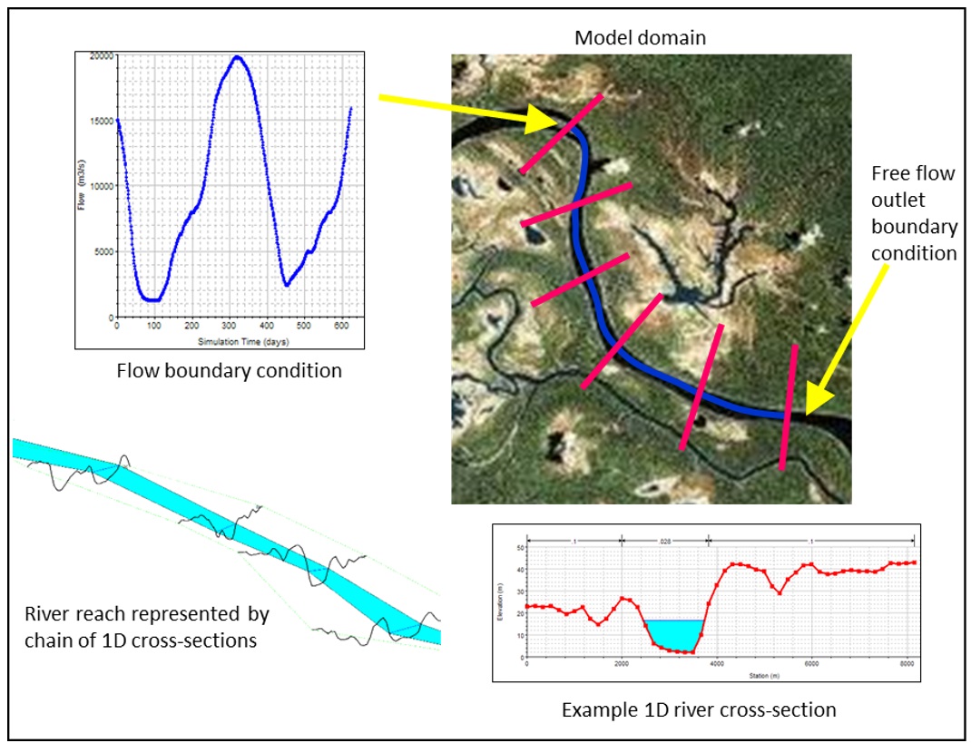
A more sophisticated form of model is constructed from a chain of points along the river with the river geometry provided as topographical cross-sections (see figure below). The model then solves the flow equations for the whole river in one model run. This is referred to as 1D fluvial modeling.
Figure 1: Example of a simple 1D fluvial model of a single river reach
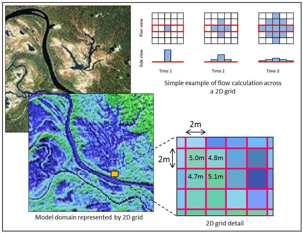
In the last ten years, 2D fluvial modeling has become much more common (see figure below). It has been made possible and popular due to the increasing speed of computers and methods of collecting detailed topography such as LiDAR. This form of model allows a more detailed calculation of "out of bank river flow" over the river floodplain, by treating the earth's surface as a series of gridded squares each with its own elevation and calculating how water would flow across this grid. Sometimes models incorporate both 1D and 2D components to allow the best representation of both the river and the floodplain.
Figure 2: Example of a simple 2D fluvial model
Another factor to consider in fluvial modeling is whether the dynamics of the flow is important for the application. It is possible to undertake modeling using a steady-state calculation assuming a single steady flow value that does not change. If the changes in flow (e.g. rising and receding flood waters) are important, then a more complex hydrodynamic calculation is required which runs with a timeseries of flows. Most software will allow the calculation of either, with steady state being simpler and faster but hydrodynamic being more accurate and essential under conditions where water is stored (e.g. on the floodplain).
As computers get faster and researchers develop ever more sophisticated modeling techniques to cover more applications, it is harder to choose an appropriate model (software) or approach without experience. In some countries, only tested and vetted models (software) are permitted to be used for engineering design or FRAs and EIAs. In addition, while some models (software) are produced commercially and can be expensive, for many applications, free and open source software have now become a professional and viable alternative (see resources list at the end of this methodology for some examples).
Building a Fluvial Model
There are many steps and decisions to be made in building a fluvial model. The main steps are shown in the figure below and described below:
Figure 3: Flood modeling procedure
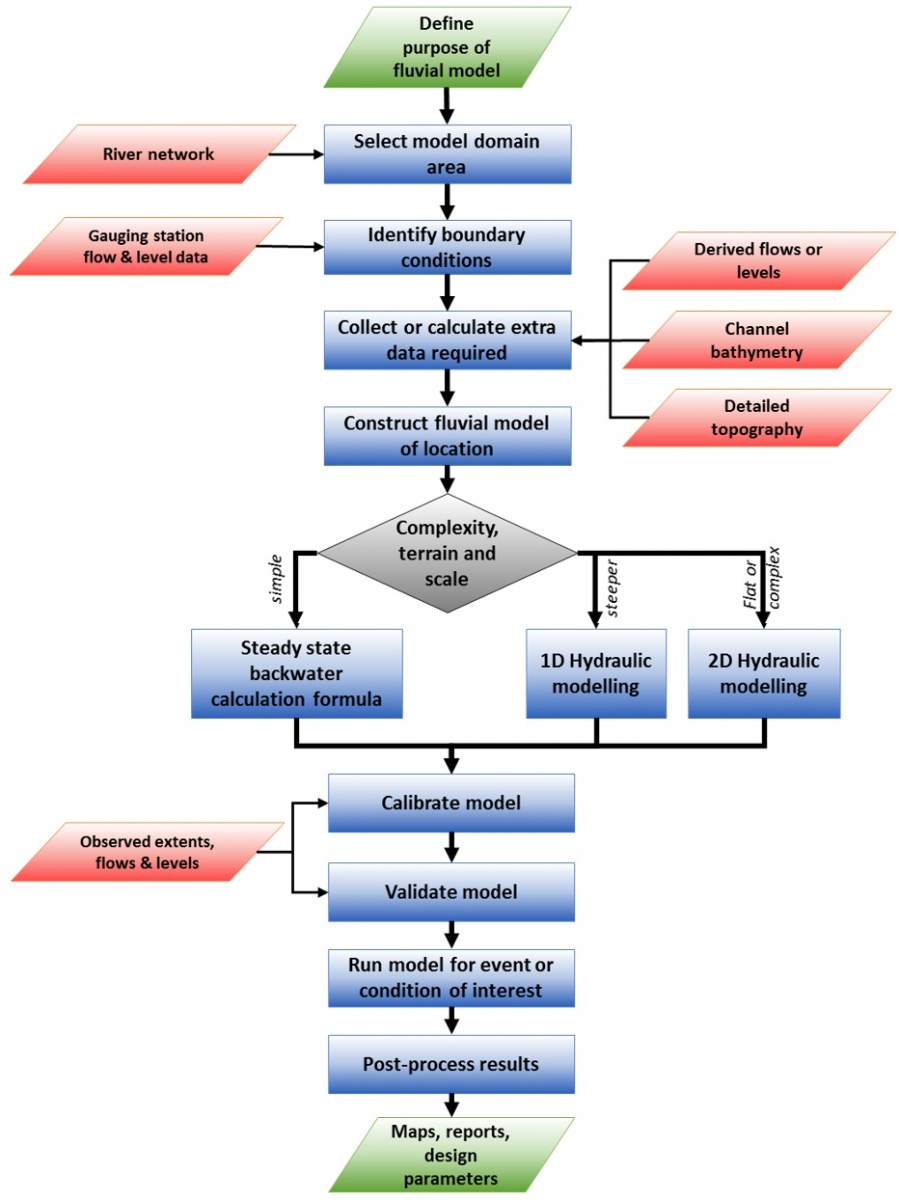
- Identify purpose of model
This is a fundamentally important step, as all subsequent decisions regarding building the model will depend on the purpose identified for the model. As explained above, there are many uses for fluvial models and the appropriate choices in terms of data, domain, model software, etc. will determine if the model is fit-for-purpose. Key choices at this stage are hydraulic model method (backwater calc., 1D or 2D) as well as run type (steady-state or hydrodynamic).
- Selection of Domain area
The domain area is "modeller-speak" for the spatial extent covered by the model. The model domain needs to be suitably big that the area for which fluvial predictions are required (area of interest) is fully covered, but is not too big that the model runs slowly or there are excessive data requirements. It is a case of developing an optimum sized model for the purpose.
- Identify boundary conditions
Often the model domain is a subset of a river system, for example, you might only model a 1-5 km reach of a river for a bridge design model. This means that for the model to run correctly, it will need to know something about the conditions outside the model domain, because rivers are continuous systems flowing from the hills to the sea. These outside conditions are known as boundary conditions, and usually consist of water levels or flow inputs at the edge of the model domain. Often the availability of data at particular points on a river, e.g. river gauge location, can help define the choice of model domain area.
- Collect data required
Once the domain and any required boundary conditions are identified, then collection of the required data can commence. Sometimes this data is readily available as existing data, such as from river gauges, or national topography data. If all the required data does not already exist, which is often the case, then specialist data collection will be needed. An example of this would be specially commissioned topographical surveys to collect river bathymetry (river bed geometry). The limited coverage of river gauges can also mean that there is no flow data readily available for boundary conditions and if this is the case, specialist hydrology methods to estimate flows at ungauged locations are required (e.g. rainfall-runoff models or transferring data from similar rivers that are gauged). For a full list of data required please see the Data Handbook Section 2.2.
- Construct model and stability test
Once the data required has been collected, the next step is to put this together into a fluvial model of the chosen domain. This step sometimes requires pre-processing of the data collected to get it into a format suitable for the chosen hydraulic modeling software. It will also require some more choices such as parameters values (e.g. friction coefficients) and model resolution (e.g. 2D topography resolution - how detailed a grid). Models that cover a large area and contain a lot of topography detail (e.g. those based on LiDAR topography, can have millions of grid cells representing the topography), can be slow to run unless you have a very powerful computer. Provided the purpose of the model does not require all the detail, the topography data can be resampled to a coarser resolution to speed the model up. At this stage, the model is test run to make sure that all the choices produce a working model that is numerically stable.
- Calibrate model
In building the model, various choices are made that will affect the results of the model. However, these choices are often not an exact science (for example, river friction is hard to measure directly) and there could be a plausible range of values to choose from. In order to select appropriate values for these parameters, the model will be calibrated. This entails adjusting these parameter choices until the model output better matches observed conditions or measurements. For example, historical records for a flood event could be used to calibrate a fluvial flood model.
- Validate model
Ideally, a model will be validated as well as calibrated, but sometimes this is not possible due to limited real world data with which to test the model. Validation is similar to calibration in that the model output is compared to observed conditions to make sure it is a realistic simulation of the real world, but unlike calibration, model parameters are not adjusted. This ensures the model is not overly calibrated to one set of conditions and is more broadly applicable. For example, historical records for a different flood event to that used for calibration could be used for validation.
- Apply model to specific conditions required
Once the modeler is confident they have a stable model that reproduces real world conditions reasonably well (it will not be perfect), the model can then be run to produce results for particular events or conditions of interest. For example, predicted changes in flows due to climate change could be used in the model to explore the effect that this would have on flood extents or depths.
- Post-processing and report outputs
The final stage of the fluvial modeling is to communicate the results to those interested in the results. This may entail some post-processing of the results to get them into a form suitable for non-specialists to understand, for example, in map and/or report form. It is common to produce a technical report of the modeling process where all important choices and details are documented.
Also see Use case Book section 3.2.2 Roads in flood affected areas for a more detailed process diagram on the linking of hydrology fluvial models, and their application to river crossings for roads.
Skills required
A fluvial model builder is a specialist technical role and is typically carried out by a hydrologist or engineering hydraulic modeler. They will be trained to Bachelor's degree level in Civil Engineering, Environmental Science or Geography and often also require an MSc to cover the specialist subjects in sufficient detail. A consultant will usually employ one or more of these specialists when undertaking fluvial modeling as part of a contract. They will require an in-depth understanding of hydrology and open channel hydraulics in order to understand the processes being simulated. They should also be experienced in the data types being used to construct the models and be familiar with both the river modeling software as well as pre and post processing software (such as geographical information systems - GIS) for communicating the results of the modeling to others, for example, in map form.
Modeling output application
The level of output detail required of a model is dictated by the model application. For example, if a user requires a general overview of which sections along a river might flood, then a simpler, coarser model might be suitable. However, if the application is the detailed design of a bridge and its piers, then it may require a very detailed engineering model. This output requirement will dictate both the detail and quality required of the input data. It is common to commission expensive topographic surveys (0.5 m - 1m spacing, <1cm precision), or even laser surveys (terrestrial LiDAR), around a bridge crossing to ensure all the engineering details can be designed correctly. For national scale flood hazard models, coarser topography can be used as the output application is to determine general areas of flooding rather than cm precision, and collecting too much detail at that scale can be costly and prohibitively long computer run times. Ideally the quality and detail of the flow and level data used in a model should also be of a level similar to that for the topography or bathymetry. However, this can be difficult, as long records are sometimes required or measuring a particular event requires a gauge to be in place at the time of the event which may have passed. In these cases it is common to use sensitivity analysis to explore a range of possible flows or levels to see if this fundamentally changes the conclusions from the model.
Other Resources and links
An excellent and easily understood guide is the UK Environment Agency Flood Risk Assessment modeling guide. It includes a list of survey requirements for collecting extra topography data and a checklist on reviewing modeling reports.
Modeling Software
Most of the hydraulic modeling software packages (free and licensed) provide excellent manuals, tutorials and even hydraulic reference guides that are a useful resource for learning more about fluvial modeling. Some examples are shown below (not exhaustive or specifically promoted):
Some open modeling packages:
HECRAS (1D/2D) http://www.hec.usace.army.mil/software/hec-ras/
IBER (2D irregular mesh), http://iberaula.es/web/index.php
OpenLISEM (2D regular grid) , http://blogs.itc.nl/lisem/
Some commercial modeling packages:
Mike Flood (1D/2D), http://www.mikepoweredbydhi.com/products/mike-flood
Flood Modeller Pro (1D/2D), https://www.floodmodeller.com/global/
TuFlow (1D/2D), http://www.tuflow.com/
Other links
EA fluvial design guide - engineering design
British Society of Geomorphology - fluvial modeling guide
http://www.geomorphology.org.uk/sites/default/files/geom_tech_chapters/5.6.4_Fluvialmodeling.pdf
Last update:
19-07-2016