Saint Vincent and the Grenadines
Legislation and planning process in Saint Vincent and the Grenadines
Authors: Charisse Griffith-Charles and Mujeeb Alam
Links:
- Comparison of legislation and planning frameworks for five countries
- Generating a database of historical events
- Multi hazard comparison at national level
- Multi hazard exposure analysis
Saint Vincent and the Grenadines (SVG) is comprised of 32 islands, islets, and cays, the largest being St. Vincent. The country covers a total land area of about 384 km2 and has a total population of about 111,000. The Island's topography is mountainous with average temperature of 27° C, and an annual rainfall of 2100 mm. The islands are part of the Lesser Antilles Island arc, a region known for its active volcanism caused by subduction of the South American Plate and/or North American beneath the Caribbean Plate. The population of SVG and structures are vulnerable to many hazards, particularly from hurricanes, tropical storms, and geological hazards such as landslides and volcanic activity. Most construction has taken place on steep slopes, often exceeding 45 degrees, thus exacerbating the natural propensity of the land to slide during prolonged rainfall and impacts of heavy winds. Since 1900, St. Vincent has been hit by 8 named storms. The most notable are: Hurricane Allen (1980) and Hurricane Lenny (1999). Hurricane Tomas in 2010, caused an estimated EC$65 million damage to the country's agricultural sector (Lumbroso, Boyce, Bast, & Walmsley, 2011). The country is also at the risk of the La Soufriere volcano located on the north of St. Vincent, which may also trigger shallow earthquakes. The volcano has already erupted 5 times in the recorded history (1712-1979). The country is also at the risk of Tsunami, which may be triggered as a result of an eruption by an undersea active volcano, called Kick-em-Jenny, located close to Grenada in the north. According to a GFDRR report (2010c), a significant proportion (41.6%) of the population is exposed to risk of mortality from 2 or more hazards and there is a large economic risk (41.6% of GDP) from two or more hazards.
The physical planning process in SVG
Physical planning in SVG is taking place in accordance with the Town and Country Planning Act, 1992, ( Town and Country Planning Act, 1992), and subsequent amendments in the Act. A Physical Planning and Development Board (PPDB) of 14 members has been established in accordance with the act. These members are selected from various government ministries/departments, and other public offices. The Cabinet selects the Chairman and the Deputy Chairman from the board members. The main functions of PPDB, as outlined in the Act 1992 are to;
- Institute study of town and country development;
- Ensure the orderly and progressive development of land and the proper planning of the country and town areas;
- Prepare national, regional, and local development plans and keep under review;
- Control development according to the provisions of the Act.
The Physical Planning Unit (PPU) is responsible for the implementation of the Act and board directives. In this arrangement, the Head of the PPU is Secretary to the board and Chief Executive Officer (CEO). In this respect, the planning unit is responsible for development planning (figure 3.3) and development control as the regulatory body.
Physical Planning Legislation in SVG
- The Town and Country Planning Act CAP No. 334 volume 10;
- The Waste Management Act, Cap 419 volume 13
- The Environmental Health Services Act, Cap 285 volume 9
- The Wildlife Protection Act CAP 72 Volume 2
- The Forest Resource Conservation Act, CAP 60 Volume 2;
- The Marine Parks Act CAP 62 volume 2
- The National Parks Authority Act, CAP 326 volume 10
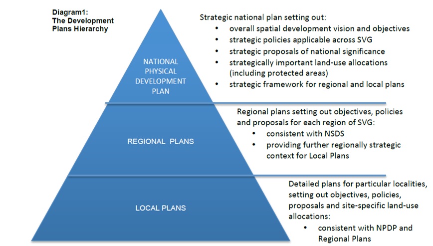
Figure 1: The Hierarchy of plans envisaged by the Act 1992 (Kemp, 2013)
In the course of preparation of development plans (See figure 3), the Board is to consider the population distribution and future growth, trends in economic and social development, prevailing physical and environmental conditions, foreseeable need and availability of land for agriculture, forestry, national parks, public spaces, and coastal management matters. In fact, the national development plan should take the strategic framework by creating strategies for development, focus development along broad statements and out of those broad statements go down to the regional and local area plans. A development plan is to be approved by the Cabinet for its enforcement. It is important to review a plan after 5 years of its formal approval and conduct fresh surveys to feed the plan. However, with the permission of the concerned Minister, the Board may review it any point in time. A national physical development plan (for a period 2001 to 2020) is already prepared for SVG. However, it is still in draft form and currently efforts are underway in preparing a new national plan. Few local area plans are already developed. No regional plan is produced.
For land development in SVG approval of the Board is mandatory as dictated in the Act. According to the planning law, Section 16(1) “Subject to subsection (3) and notwithstanding any provisions in any other law, no person shall carry out, or cause to be carried out, any development except under and in accordance with the conditions of a grant permission for development given in writing by the Boardâ€. The application is to be submitted on a prescribed form attaching required documents and drawings for the review of the Board. In dealing with an application for the grant of permission for land development, the Board has to take into account provisions of approved national, regional, or local development plans and environmental impact assessment studies of the area. After reviewing the application for its conformity with existing regulations, guidelines, existing policy, the Board may grant permission for land development with or without conditions or refuse the permission for the stated reasons. Any person who, starts development work without prior approval of the Board or implement development work without complying with agreed terms and conditions, commits an offense and is liable for punishment as per the law.
Status of hazard risk information in SVG
There are relatively limited hazard maps available for SVG. Mainly landslide susceptibility maps exist. The list of hazard maps prepared by consultants/institutions under different projects is provided at Table 1.
Table 1: List of different hazard maps produced for Saint Vincent
|
Type |
Purpose/ Description |
Coverage |
Scale |
Date produced |
Author/Consultant |
Source of this information |
|---|---|---|---|---|---|---|
|
Landslide |
To map landslides in the island |
Entire Island |
1:25,000 |
1988 |
Jerome deGraff |
(CDERA, 2003b) |
|
Landslide susceptibility map |
To map landslides in the island |
Saint Vincent |
Unknown |
|
|
Physical planning, SVG |
|
Landslide inventory |
Compilation of historical records of landslide events of last 20 years |
Entire Island |
|
|
|
Physical planning, SVG |
|
Volcanic hazard map |
To study volcanic hazard of Saint Vincent |
Saint Vincent |
Unknown |
|
Seismic research center, UWI |
(Catherine, 2010) |
|
Landslide susceptibility map |
Under the CHARIM project |
Saint Vincent |
Unknown |
February 2015 |
ITC |
ITC |
|
Landslide susceptibility map |
Under the CHARIM project and part of an MSc thesis |
Saint Vincent |
Unknown |
February 2015 |
Diana |
ITC |
Inclusion of disaster risk reduction in physical planning policies and development work in SVG
The Town and Country Planning Act 1992, does not make any specific provision of use of hazard information and related instruments for development planning. The Physical Planning Unit (PPU) controls physical development by making use of existing guidelines and other regulatory instruments such as national building codes and regulation, planning guidelines, environmental impact assessment regulations, and coastal zone management. The physical planning unit is using landslide susceptibility maps in making decisions related to sub-divisions. However, due to large scale differences between the landslide map and the sub-division working scale, the usefulness and applicability of hazard maps becomes limited. These maps can only provide an overview situation of the area hiding local details.
Nonetheless, there is reorganisation within the physical planning unit for the mainstreaming of DRR in their development work. For instance, the methodological framework for the development of national physical development plan,has specifically recommended inclusion of climate change mitigation and hazard and risk management (e.g. restricting development in highest risk areas, mitigation measures, requiring hazard assessment when development is proposed, and preventing development that may increase hazard risk.) (Kemp, 2013).
References
Catherine, J. L. (2010). Analysing Vulnerability to Volcanic Hazards : Application to St. Vincent. University College London.
Global Facility for Disaster Reduction and Recovery (GFDRR). (2010c). Disaster risk management in Latin America and the Caribbean region : GFDRR country notes (SVG).
Government of SVG. (n.d.). About SVG. Retrieved November 17, 2014, from http://www.gov.vc/index.php?option=com_content&view=article&id=13&Itemid...
Government of SVG. Town and Country Planning Act, 1992 (1992). SVG.
Isaacs, Philmore A. B. 2013. St. Vincent and the Grenadines Land Policy Issues Paper. Report prepared for The Social and Sustainable Development Division (SSDD) of the Organisation of Eastern Caribbean States (OECS), Morne Fortune, Castries, Saint Lucia.
Kemp, S. (2013). St Vincent and the Grenadines national physical development plan : Preliminary methodological framework report.
Robertson, R. E. A. (2003). Making Use of Geology - the relevance of geology and geological information to the development process in St Vincent and the Grenadines, 1–9.
The University of the West Indies. (2011). Seismic Research Centre. Retrieved November 16, 2014, from http://www.uwiseismic.com/Maps.aspx